The Mike Moore administration should rethink its $1-a-year, 50-year lease plans for some downtown properties. In recent years, the city of Jeffersonville forced businesses to close and residents to leave downtown all for the promise that this land would be put to a better use.In theory, this canal district plan — promoted under former Mayor Tom Galligan — would have eliminated flooding, increased assessed property values, private investment, job creation, revenues to the tax increment financing district and created a downtown amenity that would draw people to visit. Over time, all these factors would result in a downtown we could be proud of and one full of economic activity.We all know Mayor Moore was not a supporter of the canal plan. He believes this plan was way too expensive and over-hyped. That’s fine; now as mayor we see that he continued the downtown property purchases and continued to push for borrowing and bonding $11 million to improve this area. I worry that now that we have this property, there isn’t a proper plan to develop it, grow jobs and grow the tax base.I was taught don’t complain unless you have some suggestions to improve the situation. I’ll limit mine to three:1. Put out an request for proposal to large, deep-pocket developers for a majority of the property. Have this RFP reach out beyond Metro Louisville and make sure they are seen in big metro areas. Let experienced, well-funded entrepreneurs/developers suggest ideas on what they would do with this prime property located near downtown Louisville. If they come up with a good idea, go for it. And remember they will also have to offer a drainage plan to do something with all the water.[Editor’s note: On Tuesday evening, after this letter was submitted, the Jeffersonville Redevelopment Commission discussed moving forward on seeking RFPs for the properties and area, and a more detailed RFP is expected to be presented at that board’s next meeting].2. Create an art district plan and model it after other successful plans like Paducah, Ky.’s Art Relocation Program (http://www.paducahalliance. org/lowertown-arts-district). Some key aspects are that this district should not be in a prime location, should have a defined location, defined criteria and defined goals. Without a plan you are arbitrarily picking winners and losers and discriminating on what you think is worthy and/or artsy, which is a bad idea. 3. If the big RFP does not go well, try to get a big local entity to be an anchor/draw to the area. Just look at New Albany and how the YMCA helped downtown or how Indiana University Southeast and the Purdue University in New Albany helped the Charlestown Road area. How about we call Ball State University or Notre Dame University and ask if they want a branch location in downtown Jeffersonville? I personally think Notre Dame South has a good ring to it. We can do much better then the current haphazard lease giveaway plan that is being proposed by the Moore administration. As taxpayers who financed the purchase of all this land, we should demand more and to those we forcibly displaced, we owe much more.— Ed Zastawny, Jeffersonville city councilman, District 2
Thursday, February 28, 2013
Wednesday, February 27, 2013
Sports Complex Offers Great Opportunity
The Jeffersonville Parks Department has announced that it is planning to construct the above sports complex. It is expected to be complete in August of next year. Several soccer fields and football fields will be on the grounds as well as an indoor facility.
As luck would have it, I recently had the opportunity to see first hand a multi-purpose/multi-court facility. It had drawn several traveling teams from around the region for that weekend. The thought that such an event could take place in Jeffersonville is a very attractive one. Just think of 8 soccer teams descending on Jeffersonville for a weekend. If each team brings 15 families of four people, that's nearly 500 hundred people eating, shopping and sleeping in Jeffersonville. Think about what that could do for local restaurants and hotels.
And while some people have worried about the location, let me say it's fine. The complex that I had a chance to visit was in a similar location off of the interstate. And there were no hotels off of that exit either. Yet they were still able to attract the event. I see no reason why Jeffersonville would be any different.
Now as far as traffic goes, let me say this: I'm not the least bit worried about it. And guess what, I would be directly affected by the traffic. Most weeks would just be a normal schedule which wouldn't result in too many cars. The few weeks that they were to have a big event, it's not like families would be just driving back and forth from the complex creating a constant flow of traffic. They would drive there. Perhaps leave for lunch if it was all day event and then return and leave when the event is complete. Maybe at most you would have two times (the very beginning and end) when you could have a large amount of traffic in the area. So what, it might take me a few moments longer to get in and out of my neighborhood during those few times. I think I'll live.
And no, my neighborhood wasn't contacted to attend the meeting. But unlike some in this city, I don't feel the need to feel bitter over nothing. Especially when the end result has huge possibilities for the city and its business owners.
But as usual, I'm more interested in the progress and growth of our city than any personal petty issue. And this is a great opportunity toward that goal.
Sunday, February 24, 2013
The Lousy Weather's Weekend Wrap Up
Now, on to the Wrap Up:
-Well the big story of the week was the back and forth between mayor Mike Moore and county commissioner Rick Stephenson. What started as communication to try and come to an agreement on a payment deal on past due money owed to the animal shelter. What it turned into was a he said/he said where Stephenson claims that Moore offered the county a deal, but only if Tom Galligan was removed from airboard. Moore of course denied it. You can see WHAS 11's story here. And for those of you who are playing the at home game, this would be the third time that Moore has been on the news recently and the third time its been embarrassing to the city.
First let me say that if two weeks ago I felt like I was bashing my head into the wall, then when this story came out I was down right giddy. And what made it even better is, that while most of little mikey's supporters knew just to keep quiet and hope that it blows over quickly, Tina was not that smart. Can't say that I'm surprised. And she just kept letting me hammer her because she was too stupid to just shut up. (I know, you're shocked too!) I tell you it was like shooting fish in a barrel. Really stupid fish that think the gun is a camera and keep swimming to the top of the barrel to say "cheese". She didn't want to say anything bad about either candidate so she just kept saying nothing and looking really stupid and petty trying to play word games to defend little mikey.
Okay, now that that is out of the way, lets get to the heart of this matter. Given the two options, I believe Mr. Stephenson. I don't know him, but I have to say that I have no reason to not like him. No, I didn't vote for him, but that doesn't mean that I still can't like him. And I may vote for him next time. I have made it no secret that I'm not a one party guy. And the fact he is indeed interested the progress and growth of our area to cross party lines to do what is best for the county is a great sign for us all. The fact that he also will call out Moore for his petty and unethical act is even better. It seems that, much like his fellow Republicans on the city council, Stephenson will not be bullied by Moore.
Then there is the reality of the situation. Mike Moore used a debt owed to the city, one that he started while a commissioner, as bargaining chip to try and oust a former political rival. Childish. Petty. And unethical.
And let's do the math real quick. Democrats, city council republicans, and now a republican commissioner have all battled with Moore. To me that adds up to Moore being the problem. But I think everyone already knew that. The only ones who wont admit that are the ones who don't have the city future as a priority.
Let me again say thank you to Commissioner Stephenson for standing up for what is right and crossing party lines. Both sides could use more people like you.
-Haven't gotten enough Moore yet? Well then there is this. Apparently little mikey said this week that he will listen to any body who wants to come in and build a canal. Really? Didn't that already happen. Didn't you run them off or ignore them? Hey mikey, we aint fallin for it.
-Want Moore? Too bad. Your getting it for desert too. So the council was again trying to decide on whether or not to approve a bond for the pump at Cane Run. And Mike Moore was there to give them the information. So he says. Have a look see:
-I will be back on Tuesday to get to all the non-Moore-on stuff. Try and enjoy tomorrow. Until later, feel free to comment below and have a great week!
Friday, February 22, 2013
The Weekly JAML
-We start in New York where 38 year old George Leutz of Manhattan claimed the world record for marathon video game playing by playing Qbert for 84 hours! Wow! "How can you play a game for 84 hours?" Well, you earn a 5 minute rest period for every hour played. So then you bank your time and take it every 9 hours like Mr. Leutz did. He should be an expert at it. This is his FIFTH attempt. And in two years, writers will be studying his life for a remake of the 40 year old virgin. So he's got lots going for him.
http://www.nj.com/hunterdon-county-democrat/index.ssf/2013/02/hunterdon_arcade_owner_84-hour.html
-For most men, a round of golf is merely an excuse to get out of the house, meet the guys, drive a golf cart, drink a few beers and relax. That is not what is is for Daniela Holmqvist.
Half the men in America just said to themselves "well its not worth all that."
-And lastly, when you have nothing else for your post, put up the bear falling on to the trampoline story:
Thursday, February 21, 2013
New Poll!
We have a new poll up. This time its about the canal. The question is not whether your in favor or not, just whether it will happen or not.
WINTER WEATHER ADVISORY
Winter Weather Advisory
URGENT - WINTER WEATHER MESSAGE NATIONAL WEATHER SERVICE LOUISVILLE KY 326 AM EST THU FEB 21 2013 ...PERIOD OF WINTRY WEATHER EXPECTED ACROSS SOUTHERN INDIANA AND PORTIONS OF NORTHERN KENTUCKY TONIGHT... .A WINTER STORM OVER THE EASTERN PLAINS IS FORECAST TO MOVE EASTWARD AND INTO THE OHIO VALLEY TONIGHT. PRECIPITATION IS FORECAST TO DEVELOP FROM WEST TO EAST DURING THE EVENING HOURS. WITH NEAR SURFACE TEMPERATURES EXPECTED TO BE NEAR FREEZING THIS EVENING...A WINTRY MIX OF FREEZING RAIN AND SLEET IS EXPECTED TO DEVELOP. WARMER AIR WILL EVENTUALLY MOVE IN FROM THE SOUTH OVERNIGHT RESULTING IN THE MIXED PRECIPITATION CHANGING OVER TO PLAIN RAIN BY THE TIME THE FRIDAY MORNING COMMUTE BEGINS. INZ076>078-083-084-089>092-KYZ030-031-034-039-212100- /O.NEW.KLMK.WW.Y.0007.130221T2300Z-130222T0600Z/ ORANGE IN-WASHINGTON IN-SCOTT IN-DUBOIS IN-CRAWFORD IN-PERRY IN- HARRISON IN-FLOYD IN-CLARK IN-JEFFERSON KY-OLDHAM KY-SHELBY KY- ANDERSON KY- INCLUDING THE CITIES OF...PAOLI...SALEM...SCOTTSBURG...JASPER... MARENGO...TELL CITY...CORYDON...NEW ALBANY...JEFFERSONVILLE... LOUISVILLE...LA GRANGE...SHELBYVILLE...LAWRENCEBURG 326 AM EST THU FEB 21 2013 /226 AM CST THU FEB 21 2013/ ...WINTER WEATHER ADVISORY IN EFFECT FROM 6 PM EST /5 PM CST/ THIS EVENING TO 1 AM EST /MIDNIGHT CST/ FRIDAY... THE NATIONAL WEATHER SERVICE IN LOUISVILLE HAS ISSUED A WINTER WEATHER ADVISORY FOR FREEZING RAIN AND SLEET...WHICH IS IN EFFECT FROM 6 PM EST /5 PM CST/ THIS EVENING TO 1 AM EST /MIDNIGHT CST/ FRIDAY. * TIMING: PRECIPITATION IS EXPECTED TO BEGIN BY LATE AFTERNOON ACROSS THE ADVISORY AREA. INITIALLY THE PRECIPITATION WILL START OFF AS A MIX OF RAIN AND SLEET AND THEN CHANGE OVER TO FREEZING RAIN. WARMER AIR IS FORECAST TO MOVE IN AFTER MIDNIGHT RESULTING IN THE FREEZING RAIN CHANGING BACK OVER TO PLAIN RAIN. * MAIN IMPACT: SOME ICING WILL BE POSSIBLE ON ELEVATED OBJECTS AND SLICK SPOTS WILL BE POSSIBLE ON AREA ROADWAYS...ESPECIALLY BRIDGES AND OVERPASSES AND UNTREATED ROADWAYS. MOTORISTS SHOULD SLOW DOWN AND BE PREPARED FOR HAZARDOUS DRIVING CONDITIONS THIS EVENING. PRECAUTIONARY/PREPAREDNESS ACTIONS... A WINTER WEATHER ADVISORY MEANS THAT PERIODS OF SNOW...SLEET...OR FREEZING RAIN WILL CAUSE TRAVEL DIFFICULTIES. BE PREPARED FOR SLIPPERY ROADS AND LIMITED VISIBILITIES...AND USE CAUTION WHILE DRIVING.
Tuesday, February 19, 2013
Winter Weather On The Way
A storm system will approach Jeffersonville on Thursday evening. The storm is expected to spread wintry precipitation across the area. At this time it looks as though it period of sleet and freezing rain. This will happen in the overnight hours and should change over to plain rain before Friday mornings rush hour. Expect the National Weather Service to issue at least some kind of statement on this later today. At this time this does not appear to be a major event. However this could cause a few slick spots in the overnight hours Thursday. As more information becomes clear I will share with you on the blog.

Monday, February 18, 2013
The Rant On Where I've Been!

When I first started missing posts, it was a simple matter of work got very busy at the same time, the woman with whom I live with that I'm related to by marriage, also got a very busy social calendar going. The result was that I was literally coming home from work, to change and then leaving without doing another thing. This left no time for the blog.
Oh, sure, I could have taken time from work or Mrs. JAML's events to post on the blog. But since the blog neither pays me nor decides whether I sleep on the couch, I decided the best course of action was just to take a week off.
Now, during that week, a thread gets started about the canal on the chatter. Which rehashes the same old tired arguments. Quite frankly, I'm sick of talking about the canal.
Yes it is a wonderful idea/project that is worth every penny and ounce of sweat that goes into it. It was studied before hand and well thought out. It would have been a boom to our downtown.
Sadly, at the very least it is on hold until the next administration because of people who lack vision. Either because they can not see past their own selfish petty personal wants (like MBHeights) or because they just plain lack vision and understanding about how things work in the world today.
The fact is that those people did not want to see the canal because they were afraid it would succeed. And when everyone saw that it succeeded, well then that would threaten their petty self interest.
Do you want an example of this? Well lets take the new post on the canal on the CCC, in which Jules points out that Oklahoma City built a canal with great success. MB asks how that is progress. Really? The article told you how it was progress. But that progress threatens MB's selfish look on the world, so he would just like to dismiss the facts presented in the article (as he probably did in the study that went into the decision to build the canal) and thus, dismisses his own credibility,
Then the jabs started to fly on the thread. That's fine with me. But here's the deal. MB is only going to get on posters that are not in line with his way of thinking. People who he agrees with can throw out whatever barbs they want to the other side because they are helping his cause. And remembered he is threatened by people who don't believe in his way of thinking.
Want proof? Well Quasar, who like Granny, I have much respect for even though we may disagree, had to point out to HoosierTaxpayer that a previous post was in violation of the term of use agreement. Not MB who had posted in between HT's post and Q's reminder. He was willing to over look it because it was on his side.
Then Kelley tries to attack me in ways that are going around the "letter of the law" but are definitely in violation of the "spirit of the law". That's fine. It was an easy comeback as pointed out in the post below and quite frankly she was not that creative. Although that would not come as a surprise to anyone who has ever read her writing. Although, if you ever have trouble falling asleep... oh never mind.
Then you have Tina, who loves to stick her nose into every one's business, because she has the same problem that MB has. People who think differently than her, are a threat to her view on how the world should work.
At this point, I just began to feel like I was trying to knock down a concrete wall by slamming my head into it repeatedly.
And then suddenly, I just felt burnt out. Probably just a combination of all the things involved, but honestly, I didn't even want to pull up my own site. And I haven't until today.
But when you see people like Jules posting facts about like projects because she wants more for Jeffersonville, it reminds you that there are people out there with the city's future's best interest at heart and that we are not alone. And it reminds you that Jeffersonville, our home, is worth the fight. Not just to make it better than what it is. But to make it the best she can be. This lovely lady called Jeffersonville has been very good be to me. I owe her at least that much. So I'm willing to do what the other side is not. I'm willing to break down that cement wall that stands in the way between Jeffersonville and her future. Even if it means I feel like I'm bashing it with my head.
Monday, February 11, 2013
Saturday, February 2, 2013
The 2009 Ice Storm's Weekend Wrap Up
Yes I should have done this last week, but you know, MLK Day has had a snowball effect.

While the 1994 snow storm might be a memory from long ago that not everyone was witness to, the ice storm of 2009 is still fresh in our memories. Its the only ice storm I remember happening here in Jeffersonville. On Tuesday night January 27th, 2009 a light mix of sleet and snow began to transition to freezing rain. And then it started pouring. I mean it rained very hard. Problem was that the temperature never got much above freezing. While temperatures near freezing kept the roads from becoming ice rinks, it wasn't nearly as kind to trees and power lines. I remember going to bed that night with a solid glaze already on the grass and plants. When I awoke the next morning, I went out to watch t.v. to see how bad it was. While sitting there, I heard a boom. Realizing that I had heard a transformer blow, I walked outside to investigate first hand. Still dark outside, I stood in awe of the flashes of light from the distance with delayed sound of the explosions from the failing electrical grid around me. And the sounds of trees I couldn't even see because of the darkness, crackling and then the branches snapping and falling to the ground still sticks with me more than anything to this day. As the sun began rise, I witnessed more limbs falling and found that the ice and heavy rain had caused the storm drain down the street to become clogged and left a large puddle at the end of my driveway about a foot deep. Yes I had to shovel the storm gutter of ice with me feet soaked in water as the heavy freezing rain changed over to one last burst of heavy snow. That burst of snow landing on the ice covered trees was the proverbial straw that broke the camels back for many tree limbs that had survived the night. The resulting power outages were historical in Kentucky. It was and I believe still is the largest power outage that Kentucky has ever faced. I know in Jeffersonville it took several days for every ones power to be restored. And with the cold temperatures it left many people looking for warm places to stay until power could be restored.
The ice storm combined with the wind storm a few months earlier did catastrophic damage to the trees of the area. Something that I think will take most of the rest of my life to return to its previous condition. The ice storm of '09 will probably stick with us like the snow storm of '94. That's for sure.
-Now on to the Wrap Up:
-It actually been a very slow week. Not much going on. I may have to leave this space empty... Wait, what? You say that there was something on the news last night? Well this is the first I'm hearing of such things.
Here's the link for those of you who have been living under a rock.
Okay, here's my thoughts:
1. This is a news story that everyone may not know.
2. There was information in the story that I had never heard.
3. Taking shots at WAVE 3 or their reporters is petty and a deflection attempt.
4. Making up conspiracy theories about how a story tones of a conspiracy is so very ironic.
5. This is not the fault of any of Moore's perceived enemies. It's not WAVE 3 fault either. They have a job to inform people. If this had happened to another town, I wonder if the locals being so critical of it would feel the same way.
6. If this story was about somebody that was viewed negatively by those bashing this story, would they be taking the same stance. I say NO. I believe that they would be saying that this was just another case of the "bad" guy getting away with it.
7. Yes this was another embarrassing story for Jeffersonville on the news. And it is not the fault of any of it's citizens.
8. No, I did not publish my post that I said I was going to earlier that day. It's written and saved and maybe one day it goes up. But reading the responses to the story, I really didn't think that it was going to have any impact, so I found no reason to go ahead with it. One day, maybe.
-In news that has to do with the city's future, Rob Waiz (yawn) presented his list of projects. Most notable was his plan to push forward with improvements along 10th street. And he and Mayor Moore wish to proceed without the 80/20 match. You know, where the city only has to pay for 20% of the project. Moore told the N&T:
"My idea was, TIF [Tax Increment Finance] dollars are there for a reason — infrastructure improvements,” he said. “Tenth street is vital to the success of Jeffersonville. We have the dollars to make this project happen.”
Wasn't mikey's platform one of fiscal conservatism Doesn't seem very conservative to me. We could use those funds on something else somewhere else in Jeffersonville. Essentially we could do more with less. Wait a minute. Wasn't that one of mikey's slogans? Oh well. At least he only has the best intentions. I mean it's not like he has any interests on 10th street. Wait a minute...
-The new governor visited River Ridge for the "Grand Openning" of Amazon. He also visited the site on the new east end bridge. And exciting things are happening at both places.
Steps are being taken for the construction of the new bridge. Let there be no doubt. The east end bridge will happen, and it will happen before this decade is over. Drop the pessimism and enjoy the process now. This will be neat to watch and will be good for the entire region, but especially for Jeffersonville.
And River Ridge announced that they expect to announce some new tenants very soon. It's too bad that Jeffersonville had such a negative growth environment. Wait...
-What a weather week huh? We've had everything. Luckly it is winding down and looks to be calm starting tomorrow. As always I will have any important weather info for you right here on the blog. Well except at 4a.m. like the other morning as I don't necessarily always wake up at that time for the weather. It is what it is.
-That should wrap it up for this weekend. I'll be back later in the week. As always feel free to comment below (careful with the delicate story though) and like the Facebook Page. I'll be back later in the week. Have a good week everyone!

Friday, February 1, 2013
Winter Weather Advisory For Jeffersonville
From the NWS:
URGENT - WINTER WEATHER MESSAGE
NATIONAL WEATHER SERVICE LOUISVILLE KY
1123 AM EST FRI FEB 1 2013
...WINTER WEATHER ADVISORY IN EFFECT FROM 1 AM EST /MIDNIGHT CST/
SATURDAY TO 7 AM EST /6 AM CST/ SUNDAY...
...WINTER WEATHER ADVISORY IN EFFECT FROM 1 AM EST /MIDNIGHT CST/
SATURDAY TO 7 AM EST /6 AM CST/ SUNDAY...
THE NATIONAL WEATHER SERVICE IN LOUISVILLE HAS ISSUED A WINTER
WEATHER ADVISORY FOR SNOW...WHICH IS IN EFFECT FROM 1 AM EST
/MIDNIGHT CST/ SATURDAY TO 7 AM EST /6 AM CST/ SUNDAY.
* TIMING: ONSET OF LIGHT SNOW WILL BEGIN A LITTLE AFTER MIDNIGHT
ACROSS SOUTHERN INDIANA...BY DAYBREAK OVER NORTH CENTRAL
KENTUCKY...AND INTO THE REST OF THE ADVISORY AREA BY LATE
MORNING.
* MAIN IMPACT: SNOWFALL TOTALS WILL RANGE FROM 2 TO 4 INCHES
ACROSS THE BLUEGRASS TO AROUND AN INCH ALONG A LINE FROM JASPER
INDIANA TO GLASGOW AND TOMPKINSVILLE IN KENTUCKY. THIS SNOW WILL
MAKE FOR DANGEROUS ROAD CONDITIONS...WITH UNTREATED ROAD
SURFACES QUICKLY BECOMING SLICK.
PRECAUTIONARY/PREPAREDNESS ACTIONS...
A WINTER WEATHER ADVISORY FOR SNOW MEANS THAT PERIODS OF SNOW
WILL CAUSE PRIMARILY TRAVEL DIFFICULTIES. BE PREPARED FOR SNOW
COVERED ROADS AND LIMITED VISIBILITIES...AND USE CAUTION WHILE
DRIVING
The Weekly JAML
-Ever notice live reports on the news, from events that serve alcohol, the really annoying people who show up in the back round and try to disrupt the reporter? Well one got a little too close for this reporter, but she had an interesting way of handling it.
-From the world of "who thought that would be a good idea" we get this one. You know how minor league teams LOVE their promotional nights? Well the minor league hockey team the Rapid City Rush, decided to have a college night promotion with a special halftime event.

Thursday, January 31, 2013
Winter Weather Advisory For Jeffersonville
Winter Weather Advisory
URGENT - WINTER WEATHER MESSAGE...UPDATED
NATIONAL WEATHER SERVICE LOUISVILLE KY
221 PM EST THU JAN 31 2013

...LIGHT SNOW ACCUMULATIONS EXPECTED WITH NUMEROUS SNOW BURSTS
THIS EVENING...

.WIDESPREAD AND INTENSE SNOW SHOWERS WILL DEVELOP LATE THIS
AFTERNOON ACROSS SOUTHERN INDIANA AND WEST CENTRAL KENTUCKY AHEAD
A MID LEVEL DISTURBANCE...SPREADING EAST THROUGH THE EVENING
HOURS. VERY INTENSE BURSTS OF SNOW ARE EXPECTED WITH THIS ROUND
OF SNOW SQUALLS AND LIGHT ACCUMULATIONS BETWEEN A HALF AN INCH AND
2 INCHES ARE EXPECTED. ALL INTERSTATE CORRIDORS WILL BE IMPACTED
IN SPOTS AND MOTORISTS TRAVELING SHOULD BE PREPARED FOR RAPIDLY
DETERIORATING CONDITIONS ON THESE ROADWAYS MAINLY BETWEEN 6 PM AND
MIDNIGHT EST.

221 PM EST THU JAN 31 2013 /121 PM CST THU JAN 31 2013/

...WINTER WEATHER ADVISORY REMAINS IN EFFECT UNTIL 2 AM EST /1 AM
CST/ FRIDAY...

A WINTER WEATHER ADVISORY REMAINS IN EFFECT UNTIL 2 AM EST /1 AM
CST/ FRIDAY.

* TIMING: A NEARLY SOLID LINE OF MODERATE TO...AT TIMES...HEAVY
  SNOW SHOWERS WILL SLIDE INTO SOUTH CENTRAL INDIANA AND CENTRAL
  KENTUCKY MAINLY BETWEEN 6 PM EST AND MIDNIGHT EST.

* MAIN IMPACT: NUMEROUS INTENSE SNOW SHOWERS ARE EXPECTED TO BRING
  VARYING ACCUMULATIONS BETWEEN A HALF AN INCH AND 2 INCHES ACROSS
  THE REGION. 1-2 INCHES IS EXPECTED EAST OF I-65 AND ACROSS
  SOUTHERN KENTUCKY...WITH LESSER AMOUNTS WEST OF THIS LINE. ALL
  INTERSTATE CORRIDORS WILL BE AFFECTED AND MOTORISTS ARE URGED
  TO BE PREPARED FOR RAPIDLY DETERIORATING CONDITIONS OVER SHORT
  DISTANCES.

* OTHER IMPACTS: VISIBILITIES WILL ALSO BE REDUCED BELOW A HALF
  MILE AT TIMES IN THE HEAVY SNOW SQUALLS AND WINDS WILL GUST TO
  AROUND 30 MPH...CAUSING SOME BLOWING SNOW.

PRECAUTIONARY/PREPAREDNESS ACTIONS...

A WINTER WEATHER ADVISORY FOR SNOW MEANS THAT PERIODS OF SNOW
WILL CAUSE PRIMARILY TRAVEL DIFFICULTIES. BE PREPARED FOR SNOW
COVERED ROADS AND LIMITED VISIBILITIES...AND USE CAUTION WHILE
DRIVING.
Thursday afternoon update
yes I have seen the post on the Clark County chatter. I will have a post later today blasting someone... But it won't be the mayor...
Wednesday, January 30, 2013
Some Tuesday Notes!

-Last night/early this morning was rocking, but not because of anything at city hall. Thunderstorms at 3a.m. in January. Gotta love the Ohio Valley. A weak tornado actually touched down in Harrison County near the casino. (By the way, its only a "weak" tornado as long as it doesn't affect you) Luckily I've heard of no damage here in Jeffersonville.
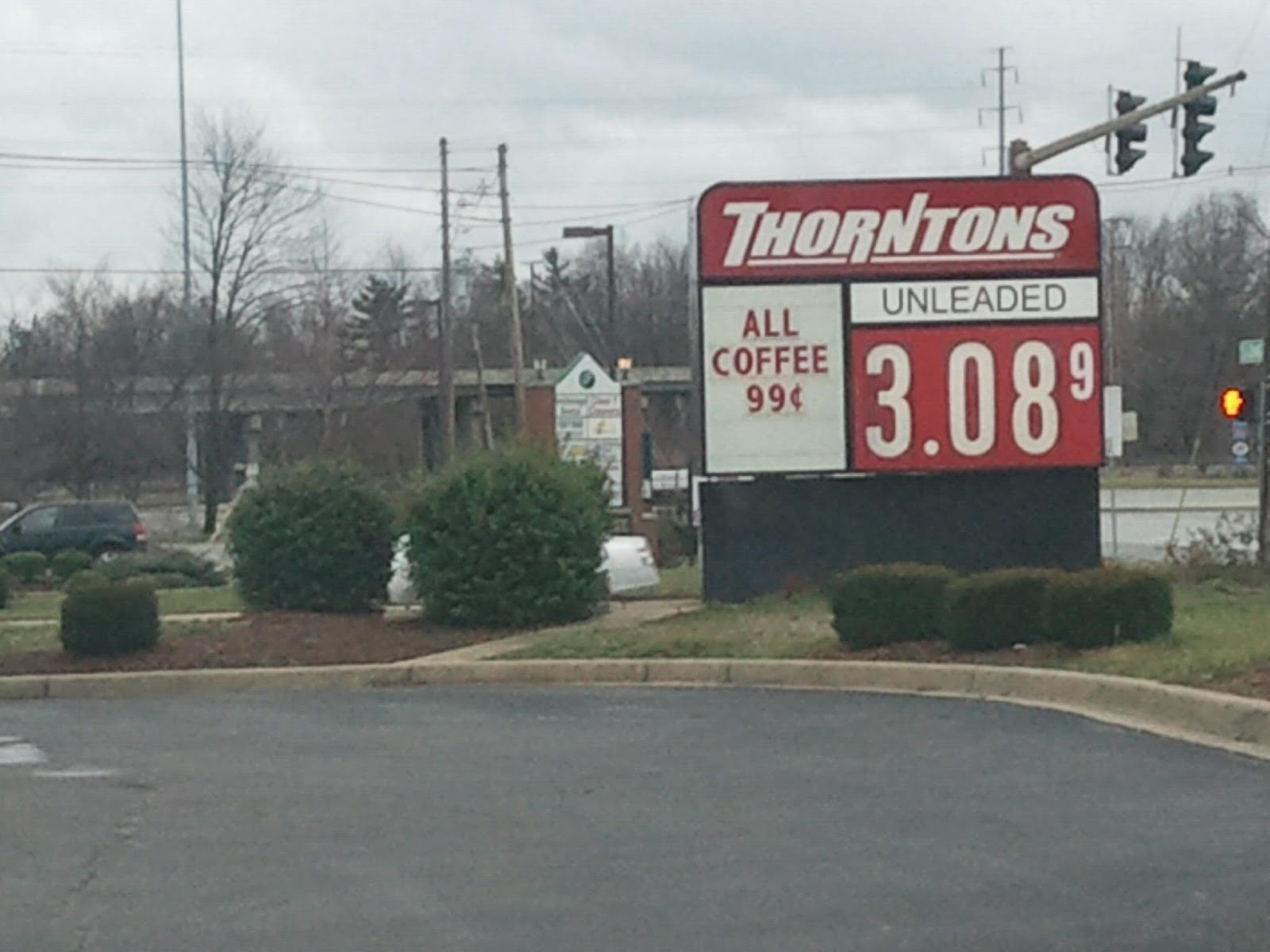
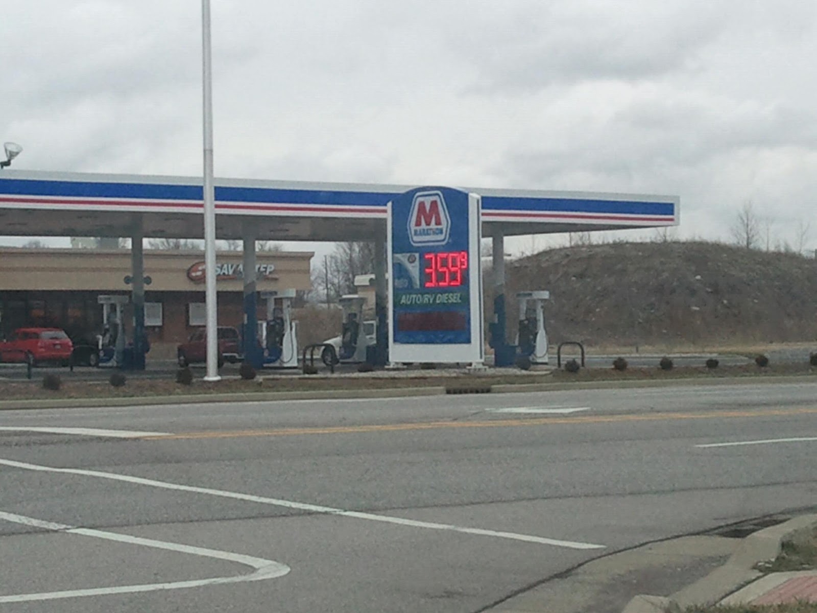
-Get you gas in Louisville! Seriously. Here's the sign at the Thorton's near JAML Corparate HQ's in the east end:
Tuesday, January 29, 2013

Monday, January 28, 2013
Chance For Severe Weather Tuesday Night
From the National Weather Service ...LINE OF STRONG TO SEVERE STORMS LIKELY LATE TUESDAY NIGHT AND
EARLY WEDNESDAY...
A RAPIDLY STRENGTHENING SURFACE LOW WILL MOVE FROM THE MIDDLE
MISSISSIPPI RIVER VALLEY TO THE GREAT LAKES BY DAWN ON WEDNESDAY.
A SOLID LINE OF STORMS WILL DEVELOP AHEAD OF A TRAILING COLD FRONT
AND WILL MOVE INTO AREAS WEST OF I-65 SHORTLY AFTER MIDNIGHT EST LATE
TUESDAY NIGHT...MOVING RAPIDLY EAST TO THE I-75 CORRIDOR BY AROUND
DAWN ON WEDNESDAY. VERY STRONG WINDS AND SOMEWHAT UNSTABLE
CONDITIONS NEAR THE SURFACE WILL LIKELY ALLOW FOR SOME INSTANCES
OF DAMAGING WINDS THROUGH TUESDAY NIGHT. ISOLATED BRIEF TORNADOES
WILL ALSO BE A THREAT WITH THIS LINE OF STORMS. STAY UP TO DATE OF
THE LATEST FORECASTS AS TIMING OF THIS LINE OF STORMS COULD VARY
SLIGHTLY.
OUTSIDE OF THUNDERSTORM WINDS...SUSTAINED SURFACE WINDS OF 20 TO
30 MPH WITH GUSTS BETWEEN 35 TO 40 MPH WILL BE POSSIBLE FROM
TUESDAY EVENING...LASTING INTO THE AFTERNOON ON WEDNESDAY.
Sunday, January 27, 2013
The 1994 Snow Storm's Weekend Wrap Up

Yeah, we should have done this last week, but MLK will always get that spot.
On Sunday January 16th, 1994 most of us went to bed expecting some freezing rain then an inch or two of snow. When we woke up on Monday morning we saw the most crippling winter storm that the area has ever seen. What started off as a brief period of freezing rain and sleet, quickly turned to snow. HEAVY SNOW!!! And a lot of it. In less than 10 hours, nearly 16 inches of snow fell across the area. Interstates had to be closed, not just because of the amounts, but because of how quickly it fell. We even had "thundersnow". I actually got to see this. I had fallen asleep on the couch that night watching t.v. and woke up about 2 or 3a.m. As I looked at the window just above me, I noticed there was a flashing light behind the blinds. I peeked between the blinds to catch one last flash of lighting. The snow falling was unbelievable. We already had several inches.
What followed was insanely cold temperatures. Days were we spent most of, if not the whole day, below zero! Louisville set their all time record low that week with -22. I remember waking up that day and my dad telling me I wasn't going playing in the snow because it was too cold. Oh the irony.
When people around here think of snow storms, this is the one that comes to mind first. We've actually had a bigger storm since then, but because of how fast the snow fell and the cold that came afterwards, this is the one that all storms will be measured against. It caused Kentucky and Louisville to tear up their old snow removal plan and come up with a new one. And if you think people panic now over the mention of snow, you should have been around for a couple of years after this storm. Hard to believe that next year will be 20 years. (I'm getting so old)
Here's to you, snow storm of '94. You are the standard.
-Now on to the Wrap Up:
-Really was a slow week again. The biggest story was that the council members who had questions about some of the mayor's expenses now say that those expenses have be adequately explained. While the State Board of Accounts will still do a review, we can and should put this in the rear view mirror. As I stated last week, (I love when I get to do that) that no one should get too upset and just let it play out. It did, and now appears to be a non-story. Whats best for the city is that everyone now moves on.
-The Redevelopment Commission was busy this week as they approved bonds for the new police station, the city's storm water conveyance system (you know the one that completely lacks any imagination or helps the city out in any other way) and a 10 year tax abatement for a Culver's to be located on Veterans Parkway.

Also, Rob Waiz didn't like it when other members questioned his tardiness in regards to him providing a 2013 projects list. Jeez give Rob a break. It's only the end of January of 2013. Whats the rush?
You can read the N&T's full story on the meeting here.
-Want to read something about the council and the mayor agreeing on something? I thought so. Well when the council tabled a request for a 7 and a half million dollar bond to pay for repairs to pumps at Cane Run and Mill Creek, they said they needed more details of the exact cost of the repairs. And you know what? Mike Moore agreed. He said that he himself has been looking for final numbers and hoped to have them for his Flood Control District meeting, but I haven't heard or read anything about it since then.
-I'll admit that I've gotten pretty lucky, but still, has anyone been better at giving you the forecast for Jeff this season?! The JAML Weather Team (probably need a better name than that) has been spot on so far. Keep and eye out this week as well. We'll go from rain tonight and tomorrow, to mid 60's on Tuesday, a chance for severe storms Tuesday night, to wintry weather the rest of the week. As always, I'll keep you up to date!
-The council did approve a ten year tax abatement for a building that will house Re/max. They've already been clearing the land out.

Waiz told the N&T here that "27 jobs, with a total salary of about $1.5 million will be added to the site".
-Finally, Mike Hutt is still watchinig over things. Over on the CCC, he has provided a list of Jeff's top paid employees and vendors for 2012. Have a look see. Neither seem to provide any "eyebrow raisers", but always interesting to see where the money is going.
-That should do it for tonight. As always feel free to comment below and to like the Facebook Page. I'll be back later in the week with another blog post and a new poll. Until then, have a good week everyone!
Friday, January 25, 2013
The Weekly JAML
-A chimp has a naughty addiction:
-Jim Irsay is one cool owner. Indianapolis is lucky lucky to have him!
-Two strippers get into a fight over a tip on stage! 'How much was this' tip you ask. 'Well it had to be at least a hundred dollar bill right' you say. Umm, try taking the two zeros off that total then you'd have your answer. But wait, it gets more ridiculous. Let me quote the story here: The women reportedly exchanged punches and pulled each other's hair until customers and other performers separated them, according to FDLReporter.com. Police were summoned as well.Sorry, no YouTube video. Just imagine your favorite Jerry Springer episode.
"I was surprised by this as we seldom receive calls for service from this business," Dodge County Sheriff Todd Nehls told the outlet.
The women, ages 19 and 23, did not require medical attention after the Jan. 17 incident, although one of them was pregnant at the time of the altercation, Chicagoist reported."