Skeletal remains found behind Faith Lutheran Church on Allison Ln. WAVE 3 has the story here.
Friday, March 29, 2013
Sunday, March 24, 2013
WINTER WEATHER ADVISORY
From the NWS:
..WINTER WEATHER ADVISORY IN EFFECT FROM 5 PM EDT /4 PM CDT/ THIS AFTERNOON TO 8 PM EDT /7 PM CDT/ MONDAY... THE NATIONAL WEATHER SERVICE IN LOUISVILLE HAS ISSUED A WINTER WEATHER ADVISORY FOR SNOW...WHICH IS IN EFFECT FROM 5 PM EDT /4 PM CDT/ THIS AFTERNOON TO 8 PM EDT /7 PM CDT/ MONDAY. * TIMING: RAIN THIS AFTERNOON WILL MIX WITH AND TURN TO ALL SNOW BY THIS EVENING. THE HEAVIEST SNOWFALL WILL OCCUR FROM SUNDAY EVENING THROUGH MONDAY MORNING...WITH ADDITIONAL SNOW SHOWERS CONTINUING THROUGH MONDAY AFTERNOON. * MAIN IMPACT: SNOWFALL TOTALS BY THE END OF THE DAY MONDAY WILL RANGE FROM 2 TO 4 INCHES. WHILE ROADS INITIALLY WILL BE TOO WARM FOR ACCUMULATIONS...THE STEADIER SNOWFALL WILL COOL ROAD SURFACES ENOUGH TO ALLOW FOR A SLUSHY ACCUMULATION. PRECAUTIONARY/PREPAREDNESS ACTIONS... A WINTER WEATHER ADVISORY FOR SNOW MEANS THAT PERIODS OF SNOW WILL CAUSE PRIMARILY TRAVEL DIFFICULTIES. BE PREPARED FOR SNOW COVERED ROADS AND LIMITED VISIBILITIES...AND USE CAUTION WHILE DRIVING.
Friday, March 22, 2013
NWS Statement
Special Weather Statement
SPECIAL WEATHER STATEMENT NATIONAL WEATHER SERVICE LOUISVILLE KY 353 PM EDT FRI MAR 22 2013 INZ076>079-083-084-089>092-KYZ030>043-230900- ORANGE IN-WASHINGTON IN-SCOTT IN-JEFFERSON IN-DUBOIS IN- CRAWFORD IN-PERRY IN-HARRISON IN-FLOYD IN-CLARK IN-JEFFERSON KY- OLDHAM KY-TRIMBLE KY-HENRY KY-SHELBY KY-FRANKLIN KY-SCOTT KY- HARRISON KY-SPENCER KY-ANDERSON KY-WOODFORD KY-FAYETTE KY- BOURBON KY-NICHOLAS KY- INCLUDING THE CITIES OF...PAOLI...SALEM...SCOTTSBURG...MADISON... JASPER...MARENGO...TELL CITY...CORYDON...NEW ALBANY... JEFFERSONVILLE...LOUISVILLE...LA GRANGE...BEDFORD...NEW CASTLE... SHELBYVILLE...FRANKFORT...GEORGETOWN...CYNTHIANA...TAYLORSVILLE... LAWRENCEBURG...VERSAILLES...LEXINGTON...PARIS...CARLISLE 353 PM EDT FRI MAR 22 2013 /253 PM CDT FRI MAR 22 2013/ ...SNOW ACCUMULATIONS POSSIBLE SUNDAY THROUGH MONDAY... A LOW PRESSURE SYSTEM WILL MOVE ACROSS CENTRAL KENTUCKY SUNDAY AND OFF TO THE NORTHEAST THROUGH MONDAY. A MIX OF RAIN AND SNOW OR ALL RAIN WILL FALL THROUGH THE MORNING AND MUCH OF THE AFTERNOON ON SUNDAY. AS COLD AIR FILTERS IN DURING THE AFTERNOON AND EVENING THIS WILL CHANGE TO ALL SNOW. SNOW ACCUMULATIONS OF ONE TO FOUR INCHES WILL BE POSSIBLE WITH THIS SYSTEM ALONG AND NORTH OF INTERSTATE 64. THE HIGHEST SNOW TOTALS CURRENTLY LOOK TO BE FROM ORANGE TO JEFFERSON COUNTIES IN SOUTHERN INDIANA. THERE IS STILL SOME UNCERTAINTY WITH THE TRACK OF THE LOW PRESSURE SYSTEM. ANY DEVIATION WILL HAVE AN IMPACT ON SNOW ACCUMULATION TOTALS. BE SURE AND CHECK BACK FOR FURTHER UPDATES ON THIS SYSTEM.

Thursday, March 21, 2013
Keep An Eye On This Weekend's Weather
There is a chance of a accumulating snow this weekend. Below is one (and I emphasize ONLY ONE) computer model for snow accumulations. I don't it will any where near this much but it does give you an idea of strong this storm could be. So just keep an eye on it.
The good news is that this time of year the roads will clear up very quickly with the high angle of the sun. But again, just something to keep an eye on.

The Laugh Is On Jeffersonville... AGAIN!

So, as I'm driving to work this morning listening to 840 WHAS, the top story of one of their newscast was another delay in the Jeffersonville ramp of the Big Four Bridge. It started off with "the bridge to no where will continue longer than expected."
Ahh, yes. Just another joke on Jeffersonville. We should be getting used to it by now.
In addition to numerous news stories recently involving the mayor that has lead to a great deal of embarrassment for the city, we can now throw this on the pile. The city that only had to complete it's own ramp while Louisville took care of their ramp and the deck of the bridge itself. People on the other side of the river are getting a great kick out of us over here.
So what's the problem now?
According to the city, it's the lighting of the ramp that is holding up construction. When the city chose to change the lighting plan for our side (originally it was supposed to uniform lighting across from the end of one ramp to the end of the other) it set the project back.
And who's idea was it to change the lighting plan?
You guessed it. Mayor Mike Moore.
Back when everything was going to be presented to the citizens so that he could receive their input on projects he decided that from the feedback he got that he should change the lighting.
Well, first, the lighting was just fine the way it was. It presented a sign of unity and continuity that we should be hoping for. Just a few weeks ago someone mentioned either on the chatter or another local site that people in Louisville think it's a different world over here and that's why many don't travel over here. God forbid that even the lights on the bridge do anything to dispel that myth.
Second, you don't change the plan if it's going to delay the project this much. Not when the reason for changing the lights is only taste in lights. They weren't ugly by any means. I see them most morning's on my commute to work. They look quite nice.
Now some have said that people were worried about the lights shining into homes. Have these people ever heard of blinds and curtains? There is a bright light that begins to shine into our bedroom every morning about 6-7 a.m. and they work quite well on keeping that light out. And I assure you that the original lights are no where near as bright.
So what we have here is not thinking through a plan properly. Now the bridge will take even longer. And now we are once again the laughing stock. Thanks mikey!
Perhaps when the bridge is finally complete, the mayor can lure a comedy club to Jeffersonville. Louisville likes laughing at Jeffersonville. Perhaps the will like to laugh in Jeffersonville.
Monday, March 18, 2013
Flood Advisory
From the NWS:
FLOOD ADVISORY FOR...
PORTIONS OF SOUTHERN INDIANA AND CENTRAL KENTUCKY
* UNTIL 1100 AM EDT/1000 AM CDT/
* AT 759 AM EDT/659 AM CDT/...TRAINED WEATHER SPOTTERS AND NWS
EMPLOYEES HAVE REPORTED MINOR FLOODING FROM THUNDERSTORMS TRAINING
OVER THE SAME LOCATIONS AND SNOW MELTING OVER THE ADVISORY AREA.
ADDITIONAL RAINFALL AMOUNTS OF APPROXIMATELY A HALF AN INCH TO AN
INCH ARE POSSIBLE IN THE ADVISORY AREA.
PRECAUTIONARY/PREPAREDNESS ACTIONS...
HEAVY RAINS ASSOCIATED WITH THE LINE OF STORMS MAY PRODUCE PONDING OF
WATER ON ROADWAYS. MOTORISTS ARE ENCOURAGED TO SLOW DOWN...LEAVE
PLENTY OF SPACE BETWEEN YOURSELF AND THE CAR IN FRONT OF YOU...AND
USE EXTRA CAUTION WHILE TRAVELING.
EXCESSIVE RUNOFF FROM HEAVY RAINFALL AND SNOW MELTING WILL CAUSE
ELEVATED LEVELS ON SMALL CREEKS AND STREAMS...AND PONDING OF WATER ON
ROADWAYS...ESPECIALLY ALONG THE BANKS OF CREEKS...STREAMS...AND
DRAINAGE DITCHES.
A FLOOD ADVISORY MEANS RIVER OR STREAM FLOWS ARE ELEVATED OR PONDING
OF WATER IN URBAN OR OTHER AREAS IS OCCURRING OR IS IMMINENT.
Sunday, March 17, 2013
How About That!
Maybe a little more snow than expected. But still not much. Get a picture while you can. 60 degrees and thunderstorms tomorrow. Who's sick?

Saturday, March 16, 2013
WINTER WEATHER ADVISORY FOR JEFFERSONVILLE. YES YOU READ THAT RIGHT.
Yes we have snow in the forecast for tomorrow. This should mainly be a rain event for Jeff. The advisory is more for northern Clark County. But snow could fall heavy in spurts tomorrow that would reduce visibility and could coat the grass and cars briefly. The ground temperatures are very warm so roads should be fine. I'll update you if anything changes.
Here's the statement from the National Weather Service:
Winter Weather Advisory
URGENT - WINTER WEATHER MESSAGE NATIONAL WEATHER SERVICE LOUISVILLE KY 345 PM EDT SAT MAR 16 2013 ...WINTER WEATHER ADVISORY SUNDAY... .A SURFACE LOW WILL MOVE INTO THE LOWER MISSISSIPPI RIVER VALLEY LATE TONIGHT ALONG WITH AMPLE AMOUNTS OF MOISTURE. MEANWHILE...TEMPERATURES WILL FALL TOWARD THE LOW AND MID 30S. PRECIPITATION WILL BEGIN IN THE FORM OF RAIN...SNOW...AND SLEET ACROSS SOUTHERN INDIANA AND EXTREME NORTH CENTRAL KENTUCKY AROUND DAWN ON SUNDAY. AS WE MOVE INTO THE MORNING HOURS PRECIPITATION WILL CHANGE TO ALL SNOW ACROSS SOUTHERN INDIANA WHERE 1 TO 3 INCHES OF ACCUMULATION WILL BE POSSIBLE INTO THE EVENING HOURS. SURFACE TEMPERATURES WILL LIKELY REMAIN JUST ABOVE FREEZING ALONG WITH ALREADY WARM GROUND AND ROAD TEMPERATURES. HOWEVER...ALL INDICATIONS ARE THAT IT WILL SNOW HARD ENOUGH AND LONG ENOUGH FOR SNOW TO ACCUMULATE... ESPECIALLY ON GRASSY AND UNTREATED SURFACES. INZ076>079-083-084-089>092-KYZ031>033-037-170300- /O.NEW.KLMK.WW.Y.0009.130317T0900Z-130317T2300Z/ ORANGE IN-WASHINGTON IN-SCOTT IN-JEFFERSON IN-DUBOIS IN- CRAWFORD IN-PERRY IN-HARRISON IN-FLOYD IN-CLARK IN-OLDHAM KY- TRIMBLE KY-HENRY KY-HARRISON KY- INCLUDING THE CITIES OF...PAOLI...SALEM...SCOTTSBURG...MADISON... JASPER...MARENGO...TELL CITY...CORYDON...NEW ALBANY... JEFFERSONVILLE...LA GRANGE...BEDFORD...NEW CASTLE...CYNTHIANA 345 PM EDT SAT MAR 16 2013 /245 PM CDT SAT MAR 16 2013/ ...WINTER WEATHER ADVISORY IN EFFECT FROM 5 AM EDT /4 AM CDT/ TO 7 PM EDT /6 PM CDT/ SUNDAY... THE NATIONAL WEATHER SERVICE IN LOUISVILLE HAS ISSUED A WINTER WEATHER ADVISORY FOR SNOW...WHICH IS IN EFFECT FROM 5 AM EDT /4 AM CDT/ TO 7 PM EDT /6 PM CDT/ SUNDAY. * TIMING: SNOW AND SLEET ARE EXPECTED TO BEGIN AROUND DAWN ON SUNDAY LASTING INTO THE EVENING. * MAIN IMPACT: 1 TO 3 INCHES OF SNOW IS EXPECTED TO ACCUMULATE MAINLY ON GRASSY AND ELEVATED SURFACES. ALL INDICATIONS ARE THAT IT WILL SNOW LONG ENOUGH AND HARD ENOUGH DESPITE SURFACE AND GROUND TEMPERATURES JUST ABOVE FREEZING. SLEET ACCUMULATIONS ARE EXPECTED TO BE MINIMAL ALONG THE I-64 CORRIDOR. * OTHER IMPACTS: HEAVILY TRAVELLED ROADWAYS MAY NOT BE IMPACTED THROUGH THIS EVENT...HOWEVER UNTREATED SIDE ROADS WILL LIKELY BE AFFECTED IN SPOTS. PRECAUTIONARY/PREPAREDNESS ACTIONS... A WINTER WEATHER ADVISORY FOR SNOW MEANS THAT PERIODS OF SNOW WILL CAUSE PRIMARILY TRAVEL DIFFICULTIES. BE PREPARED FOR SNOW COVERED ROADS AND LIMITED VISIBILITIES...AND USE CAUTION WHILE DRIVING.
Tuesday, March 12, 2013
BREAKING NEWS: ANOTHER ONE GONE
Apparently they are dropping like flies at Citt Hall. Amy Adams has been let according to Gaw.
Friday, March 8, 2013
An Update On My Post From Last Night
Okay, so just to let everyone know, where I stand on what happened last night:
-First, let me say that Quasar did offer me a chance to open my own "Bad Things Mike Moore Has Done" thread. Looking at the times of my post and his offer, I was already in the middle of writing my post when he made his.
-Second, I have no desire to open such a thread. The only reason I made my statement (on the CCC) at all was because he said there was no drama to someone who said that this was just another in a line of drama filled things that have occurred under Moore. That was my first post in the whole thread. I wasn't there to "pile on". Only made my comment to refute his claim that there has been no drama.
-Third, my post was not to "call out" or bash the CCC. I understand that written words are harder to grasp the emotion behind them. But if I was trying to "call them out" I would have said something along the lines of "you gots some splaining to do". Instead politely encouraged them to chime in as my post was merely to ask the readers of this blog if they thought I had done anything wrong. And I only posted the relevant posts from the CCC to here for that conversation.
-Fourth, I never considered deleting Quasar's comment or banning him for his choice of words. While he has those rules on the CCC, I do not here, and thus to serve any banning or editing would have been very hypocritical on my part. I have no intention of doing that and try to avoid such behavior. They have their rules (and I understand as they have a lot more posters than I do) and I have mine. I'll follow their rules while I'm there and they can follow mine here. And both should expect to be allowed to operate with in confines of those rules at the respective sites.
-Fifth, I contacted Quasar via Private Messenger today and gave an example of what I thought was a double standard. I'm not above saying that I was wrong and was hoping to be able to discuss the situation. At the very least, I had hoped to maybe (while not agreeing with him) at least understanding where he was coming from or his thinking.
What I got was being told that I was not owed an explanation and having the PM closed.
That's fair enough. It's his site. But it should be stated that the PM was actually opened a few weeks back when Quasar had some questions about the way I was running my blog. Needless to say I was much more courteous to his request than he was to mine.
I've gotten the feeling lately that Quasar was not happy with the way I've been posting on his site or on my own blog. Now at no point has Quasar tried to censor me here or there. Lets be very clear about this. And he stated in the opening of that PM that this is my blog was of course free to run it as I chose. That being said I gave his concerns thought and gave him both a thoughtful response and even asked for his input. I have no desire to be at "war" with anyone. But I get the feeling that he may have already been unhappy with me prior to last night and that it just boiled over when he read my post. That's his right also and he is still encouraged to post any thoughts here (pro or con). That's the way my site runs.
-Sixth, as far as I know, I'm still a member in good standing at the CCC, so I don't want anyone to think I have received any punishment from his site regarding any of the actions from any previous posts. And at this point I consider the deal water under the bridge. Or over the dam. Which ever you prefer.
-Finally, to ensure fairness, next week I will be asking if people think that Goliath has an unhealthy relationship with his chickens.
Feel free to comment below.
The Weekly JAML
All the news you wont see on the news:
-So in an attempt to clear his wrestling team from any distractions prior to their state tournament, Kasson-Mantorville's (Minnesota) head coach told them no cell phones. Good idea right? What could possibly go wrong? Well 14 members of the team got stuck on an elevator! Unable to call anyone, they were stuck there for over an hour and a half!
Want more one of the players openned the door with "his bare hands and belly"! It gets even better when you find out the they won the state tournament.
So, I guess good job coach!
-So you eat right. You execise. Do everything you can and then this happens to you:
Well, I'm going on an eating and drinking binge this weekend.
-Finally, you've probably seen it already, but if you haven't here is this. Enjoy!
New Poll!

This weeks poll ask whether you believe Mike Moore tried get Tom Galligan removed from Airport Board.
Thursday, March 7, 2013
I Pose A Question To My Readers
The following were post on the CCC:
But I have to pose this question to the "Powers that be"...why does there always have to be drama and turmoil with this administration? -cubette
What drama and turmoil? The Mayor or someone in his administration terminated an employee. It happens in organizations all over our city, state and country every day. The only drama I've seen so far has been what we have created here...-Quasar
I'll start with the physical altercation he had with his wife for starters.-Me
bs... we are discussing today's topic on this thread. So far the only drama that I'm seeing is being created by people that are intent on creating drama. Some people feed off of it... the choice is yours...-Quasar
So what do you think? Was this appropriate response? The original post was that this just another incident in a line of them.
I'll tell you this I went to work in Louisville the day after that incident and there was plenty of laughing going on at Jeffersonville expense.
I encourage everyone's thoughts below. Including Quasar and GG who I know stop by from time to time.
(Note: This NOT a bash the CCC thread for the sake of bashing people with opposing political views. If have a thought on this as being a running theme in protecting someone, leave it at that)
BREAKING NEWS!
City controller fired. You can read the story here.
Mike Moore is either firing people for petty reasons or he is absolutely terrible at making appointments.
Tuesday, March 5, 2013
What To Expect Tonight/Tomorrow Morning
Snow will continue to fall throughout the night until mid-morning. There could be periods of heavy snow as well.Winds will continue to be strong. The high winds combined with any heavy burst of snow could greatly reduce visibility for periods of time. Also, power outages are possible as they already being reported around the area. Two to three inches of snow will fall by the time the storm moves out tomorrow.
I'll post again later if anything changes.

Winter Weather Advisory
URGENT - WINTER WEATHER MESSAGE NATIONAL WEATHER SERVICE LOUISVILLE KY 426 AM EST TUE MAR 5 2013 ...ACCUMULATING SNOW LIKELY TONIGHT INTO WEDNESDAY MORNING... .A SURFACE LOW PRESSURE WILL COMBINE WITH A POTENT UPPER LOW OVER THE OHIO VALLEY TO PRODUCE ACCUMULATING SNOW OVER SOUTHERN INDIANA AND PORTIONS OF CENTRAL KENTUCKY TONIGHT INTO WEDNESDAY MORNING. AS COLD AIR RUSHES INTO THE REGION THIS EVENING...A CHANGE OVER FROM RAIN TO SNOW WILL OCCUR WITH SNOW CONTINUING THROUGH THE OVERNIGHT HOURS AND INTO WEDNESDAY MORNING. SOME BANDS OF MODERATE TO HEAVY SNOW MAY DEVELOP TONIGHT OR EARLY WEDNESDAY MORNING. SNOW ACCUMULATIONS OF 1 TO 4 INCHES WILL BE POSSIBLE ACROSS THE ADVISORY AREA. SNOW IS EXPECTED TO TAPER OFF BY LATE MORNING OR EARLY AFTERNOON WEDNESDAY.
Monday, March 4, 2013
Statement From The National Weather Service
..LIGHT ACCUMULATING SNOW EXPECTED LATE TUESDAY NIGHT INTO WEDNESDAY MORNING... LOW PRESSURE COMBINED WITH AN UPPER LEVEL DISTURBANCE WILL BRING LIGHT SNOW TO THE REGION LATE TUESDAY NIGHT THROUGH WEDNESDAY MORNING. FROM SOUTHERN INDIANA TO THE KENTUCKY BLUE GRASS ONE TO AS MUCH AS TWO INCHES OF SNOW MAY PILE UP. THE MOST SIGNIFICANT SNOWFALL WILL LIKELY OCCUR BETWEEN MIDNIGHT AND MID MORNING WEDNESDAY...SO THE WEDNESDAY MORNING COMMUTE WILL BE NEGATIVELY IMPACTED BY THIS LIGHT SNOW. STAY TUNED TO NOAA ALL HAZARDS WEATHER RADIO AND YOUR LOCAL MEDIA
Sunday, March 3, 2013
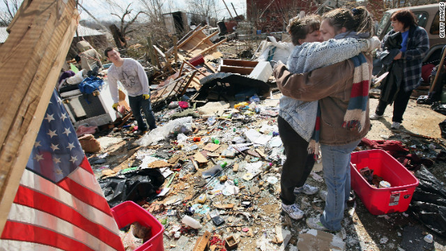
The Henryville Tornado's Weekend Wrap Up

A person on the radio that I listen to has a little saying. It goes like this: "you don't want to look out your window and see Jim Cantore standing on your front lawn." Well on March 2nd of last year, that's exactly what we all got. Storm chasers and meteorologist from all across the country converged on our area for what was expected to be one of the worst tornado outbreaks in history. Not only was there a great certainty that there would be many tornadoes, but they would be the large and most powerful ones.
I'll spare you the nerd terms and just say that there were winds at different heights blowing very fast in different directions. And unusually warm weather was going to form storms that would tap into that wind. The result was probably one of the scariest days we've been through.
It was a day I think most of us just wanted to be home. We all knew something bad was going to happen. And it did.
Henryville was hit by two tornadoes. The first was a powerful EF-4 tornado. So strong that didn't just move a school bus. But picked up a school bus and threw it with enough force to crash it through a building. Marysville was wiped off the map. And a pay stub ended up on a journey that took it to Cincinnati.
The second was a weaker tornado, but with damage done by the first, it had many projectiles to toss about leading to more damage.
It was a day we all feared. We knew something bad was going to happen. We held out hope against hope that at the end of the day we would all get to say "well the weathermen were wrong again." But they weren't. And things will never be the same because of it.


-Now onto the Wrap Up:
-The biggest story of the week occurred Friday (don't they know you're supposed to release "bad" news on Friday) when the city and county reached a tentative agreement on payment from the county to the city for use of the Ogle Animal Shelter. The county will pay the city $150,000 and waive a rental fee on a storage space the city uses in the county building. And Tom Galligan gets to keep his job on the air board. It's WIN WIN!
In all seriousness I understand the commissioners feeling some bitterness over a debt to the city that the current mayor helped bring on. But the simple matter of the fact is that the shelter could really use that money and it is good for all involved that a deal has been reached.

-Going back for just a second, I do have a question regarding a story on the disagreement that was in the N&T here. In it is the following quote:
"Merkley pointed to a provision that Stephenson said existed regarding the removal of former Mayor Tom Galligan from his position as president of the Clark County Board of Aviation Commissioners as part of the previous deal regarding county payments for the shelter.
Moore denied it was ever part of any of the previous negotiations with the commissioners.
“I have no issue with your appointments to the Clark County Airport Board and frankly, [I] have no desire to do the county’s business,” he wrote in the letter.
With that provision no longer in play, Merkley said Stephenson had claimed he was OK with everything else in the agreement to pay the county $125,000. Stephenson said he was OK with the payment, if the $125,000 would include the money owed for this year."
Okay, now either Merkley to the N&T or the N&T itself seems to indicate that there was at one point a provision that included Galligan's ouster. If that is the case, then what we have here is someone in Moore's own administration admitting that Moore lied to the whole city by way of the media about the Galligan provision.
As I've stated before, I believe Rick Stephenson and am glad Galligan will remain on the air board. And I find it highly unethical and petty that Moore would use a debt he helped create to further try and bury a former political adversary. But at no point did I say that would surprise me.
-The mayor and redevelopment commission are trying to give 50 year leases for $1 year to some arts museum people. These are taking place in the proposed canal area.
Oh, where do I start with this.
First, these things will not draw much more than diddly squat to downtown. It would be a waste of space and possible taxes.
Oh sure, they would be nice supplementary attractions that would be great to along with or in addition to a big attraction. The primary problem being here is that we don't have a big attraction yet. And I've heard of nothing that is in the works that would remotely qualify as a big attraction. Until that has been found and identified, we should not be adding any of these small attractions unless we know that they will compliment the main attraction.
Second, I don't think that Moore or Waiz personally care about how either of these perform. It is my belief that the 50 year $1 leases are just a way to make sure that no future administration can pursue the canal. Again this is petty. If you two stooges do a good enough job then you wont have to worry about another administration until most people have forgotten that a canal idea even existed. And what does it say that you are willing to throw this property and the potential tax revenue away for nothing but pay for the full amount of the tenth street project? It says that your priorities are completely out of whack and the only clear vision of the future you have presented for Jeffersonville is your attempt to try and erase the memory of the previous administration.
-Keep an eye on the weather for Tuesday and Wednesday. There is a possibility of some light snow (might be our last chance of the season). At this point it appears to be very light. But there still remains a slim chance that we could get a few inches. I'll keep an eye on it and post any information right here on the blog.
-Finally, I said my heart felt condolences to Kelley and her family.
I won't even pretend that the two of us are even cordial to one another any longer, but the hurt they all must be feeling right now is more than I can imagine and something that no one should have to go through. You and your family are in my family's thoughts and prayers.
-That should do it for tonight. As always feel free to comment below and to like the Facebook Page. I'll be back later in the week with another blog post and a new poll. Until then, have a good week everyone!
Friday, March 1, 2013

The Weekly JAML
The news you wont see on the news...
-We start with our neighbors to the north in Canada:
Nothing like having a loser coaching your kids. And is America the only country that stresses good dental hygiene.
-In our next story, we find out that America may be the only country that stresses beef actually be BEEF!:
As if we needed another reason not to buy food from a furniture store.
-Finally, speaking of things going bad with Italian food, here's this:
Apparently it happened while the guy under the costume was going to the restroom at a promotion. Someone put the costume on while the man was using the restroom (he had to take it off to go) and then just walked out of the business in the costume. That takes some big spicy meatballs. And how great is that ethnically insensitive name. Nobody likes throwing that PC crap out the window more than me.
-We start with our neighbors to the north in Canada:
-In our next story, we find out that America may be the only country that stresses beef actually be BEEF!:
-Finally, speaking of things going bad with Italian food, here's this:
Subscribe to:
Posts (Atom)