Friday, January 24, 2014

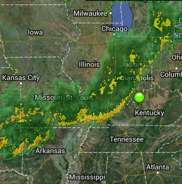
WHAT TO EXPECT TOMORROW MORNING

From The National Weather Service...

WINTER WEATHER ADVISORY REMAINS IN EFFECT FROM 1 AM EST /MIDNIGHT CST/ TO 4 PM EST /3 PM CST/ SATURDAY...

A WINTER WEATHER ADVISORY FOR SNOW AND BLOWING SNOW REMAINS IN EFFECT FROM 1 AM EST /MIDNIGHT CST/ TO 4 PM EST /3 PM CST/ SATURDAY.

* TIMING: THE HEAVIEST SNOW WILL FALL BETWEEN 2 AM AND 8 AM EST SATURDAY.

* MAIN IMPACT: ENOUGH LOW LEVEL MOISTURE WILL BE IN PLACE AS THIS SYSTEM MOVES THROUGH TO ALLOW FOR A RELATIVELY QUICK BURST OF SNOW. SNOW TOTALS LOOK TO BE THE HIGHEST ALONG A MADISON INDIANA TO GEORGETOWN KENTUCKY LINE...WHERE TOTALS WILL RANGE FROM 2 TO 4 INCHES. THE LOUISVILLE AND LEXINGTON METRO AREAS CAN EXPECT ANYWHERE FROM 1 TO 3 INCHES OF SNOW.

* OTHER IMPACTS: SUSTAINED WESTERLY WINDS OF 15 TO 25 MPH WITH GUSTS TO AT LEAST 30 MPH WILL CREATE SIGNIFICANT BLOWING AND DRIFTING SNOW. PRECAUTIONARY/PREPAREDNESS ACTIONS...

A WINTER WEATHER ADVISORY MEANS THAT PERIODS OF SNOW AND BLOWING SNOW WILL CAUSE TRAVEL DIFFICULTIES. BE PREPARED FOR SLIPPERY ROADS AND LIMITED VISIBILITIES...AND USE CAUTION WHILE DRIVING.

Saturday, January 4, 2014

Winter Storm Warning

...WINTER STORM WARNING IN EFFECT FROM 7 AM EST /6 AM CST/ SUNDAY TO 1 AM EST /MIDNIGHT CST/ MONDAY... THE NATIONAL WEATHER SERVICE IN LOUISVILLE HAS ISSUED A WINTER STORM WARNING FOR HEAVY SNOW...BLOWING SNOW...AND DANGEROUSLY COLD TEMPERATURES...WHICH IS IN EFFECT FROM 7 AM EST /6 AM CST/ SUNDAY TO 1 AM EST /MIDNIGHT CST/ MONDAY. THE WINTER STORM WATCH IS NO LONGER IN EFFECT. * TIMING: PRECIPITATION WILL BEGIN BEFORE DAYBREAK ON SUNDAY AS A LIGHT WINTRY MIX. STEADY PRECIPITATION WILL MOVE INTO THE AREA AFTER SUNRISE SUNDAY AND REMAIN MOSTLY A MIX OF RAIN AND SNOW ALTHOUGH SOME LOCATIONS OVER SOUTHERN INDIANA WILL SEE ALL SNOW THROUGH THE MORNING HOURS. A STRONG COLD FRONT WILL MOVE THROUGH THE AREA SUNDAY AFTERNOON CHANGING PRECIPITATION OVER TO ALL SNOW BY MID TO LATE AFTERNOON. SNOW WILL FALL HEAVILY AT TIMES SUNDAY AFTERNOON AND EVENING...AND THEN TAPER OFF SUNDAY NIGHT. * MAIN IMPACT: SNOWFALL TOTALS OF 5 TO 9 INCHES ARE LIKELY IN SOUTHERN INDIANA...WITH 3 TO 6 INCHES OF SNOW LIKELY IN NORTH CENTRAL KENTUCKY FROM HARTFORD TO BEDFORD INCLUDING THE LOUISVILLE METRO AREA. THESE TOTALS COULD CHANGE DEPENDING ON THE EVENTUAL TRACK OF THE STORM. * OTHER IMPACTS: HEAVY SNOWFALL RATES WILL BE AGGRAVATED BY RAPIDLY FALLING TEMPERATURES AND GUSTY NORTHWEST WINDS. SLICK ROADWAYS AND REDUCED VISIBILITIES ARE LIKELY DURING THE HEAVY BANDS OF SNOW. AFTER THE SNOW ENDS SUNDAY NIGHT...BLOWING SNOW WILL CONTINUE AS NORTHWEST WINDS GUST UP TO 30 MPH THROUGH THE NIGHT. TEMPERATURES WILL RAPIDLY FALL TO INTO THE SINGLE DIGITS BELOW ZERO BY DAWN ON MONDAY. THE ASSOCIATED WIND CHILL VALUES WILL RANGE IN THE -15 TO -30 DEGREE RANGE BY DAWN ON MONDAY. BE PREPARED FOR THIS DANGEROUS SHOT OF COLD AIR THAT WILL LAST AT LEAST UNTIL TUESDAY MORNING. PRECAUTIONARY/PREPAREDNESS ACTIONS... A WINTER STORM WARNING FOR HEAVY SNOW MEANS SEVERE WINTER WEATHER CONDITIONS ARE EXPECTED OR OCCURRING. SIGNIFICANT AMOUNTS OF SNOW ARE FORECAST THAT WILL MAKE TRAVEL DANGEROUS. ONLY TRAVEL IN AN EMERGENCY. IF YOU MUST TRAVEL...KEEP AN EXTRA FLASHLIGHT... FOOD...AND WATER IN YOUR VEHICLE IN CASE OF AN EMERGENCY

Wednesday, January 1, 2014

Snow On The Way

Expect rain to move into the area tonight.  The rain will eventually change over to snow.  About 2 inches of snow can be expected.  Temps were relatively warm today and the sun was out most of time so if the roads are treated they should stay in decent enough shape.  The only exception would be during and right after any heavier burst of snow.  Keep that in mind tomorrow and drive safe.

Sunday, December 22, 2013

City Employee To (forced?) Retire

Sources have told me that a city department head is abruptly retiring and that a replacement has already been chosen.  My source indicated to me that the retirement may have been a leave or be thrown out type situation.  I'll have more information as it becomes available.

Saturday, December 21, 2013

Tornado Watch Till Midnight

We are under a Tornado Watch until midnight tonight.  While there is a threat for tornadoes, the biggest threat from these storms will be very strong straight line winds and torrential downpours causing flash flooding.

Monday, December 9, 2013

A DECLARATION OF NEUTRALITY

With the recent declaration of war by the giant Goliath on the CCC it became apparent that the JAML blog make it stance clear.  And that stance is one of neutrality. 

While the JAML Blog may have a rooting interest on one side, the simple matter of the fact is that this will remain neutral ground. 

The truth of the situation is that the JAML Blog has friends on both sides as well as enemies on both sides.  So to declare for one side or the other is neither in our interests or our desire.  At this time.

Furthermore, the JAML Blog will accept a limited number of refugees.  The likes of Grumpy Granny, Jules, Leah and others will be allowed to pass into our boarders for safety until the conflict is resolved.

However, do not let our neutrality be misinterpreted to mean that we will standing by idly waiting to see who wins.  We will also be monitoring the combatants boarders to ensure that there are no outsiders trying to influence the outcome for one side or the other.  Or worse, arming both sides hoping for double annihilation.  We realize that there are other blogs out there that would like a long draining war for both sides so that they can use the opportunity to rise up and try to assume control.   Abbysnanna and j-pol, we will be watching.

We have sent delegates to the Oracle to discuss their current position as well.

To both parties: We are neutral at this time.  But make no mistake.  Any attempt to involve us without our permission will be met with severe sanctions.  And any act of hostility or aggression towards the JAML Blog will be met with a severe and immediate response from both us and our allies. We will use any and all force to defend our boarders.

Friday, December 6, 2013

Early (TOO EARLY) Friday Morning Update

The National Weather Service has updated their forecast.  Expect between a .25 to .5 of ice before it transitions to sleet and snow.  Sleet and snow amounts are now expected at 3-5 inches.  This put power outage in play.  Keep updated as ice is already accumulating.

Thursday, December 5, 2013

Be Prepared For Everything

This will be my only post this evening.  I have to get up early for work tomorrow.   Turned out that the office manager at The JAML Corporate HQ heard about the storm and jumped on the first flight to the Bahamas.   SOB.

As it stands right now we just in the middle of the transition zone.  Just a few miles north they are expecting a hefty snow storm.  Just a few miles to our west and southwest they are expecting a pretty decent icing event.  Just to our south and southeast they are expecting heavy rain finishing up as a brief period of snow. 

And here we are expecting primarily a sleet and snow event.  As it stands right now the forecast is for a period of freezing rain followed by an extended period of sleet and snow (which could be heavy at times tomorrow) and finishing up as all snow tomorrow night. 

A accumulation of snow and sleet of 2-3 inches is expected at this time with a thin layer of ice underneath that.  But given our close proximity to the other zones, do not rule anything out.

With the cold air moving in quicker than expected it is becoming very unlikely that this will remain mostly rain, however.  (At 6pm, Paoli was already at freezing.)  Quite frankly at this time it is more likely that this will be a bust than mostly rain.  And that is still a remote possibility.

Keep an eye and ear on the weather and proceed cautiously if you are traveling tonight and tomorrow.

It's On Its Way

It will take its time getting here but it is getting stronger and heading this way.

WINTER STORM WARNING

...WINTER STORM WARNING IN EFFECT FROM 10 PM EST /9 PM CST/ THIS EVENING TO 1 AM EST /MIDNIGHT CST/ SATURDAY... THE NATIONAL WEATHER SERVICE IN LOUISVILLE HAS ISSUED A WINTER STORM WARNING FOR HEAVY SNOW...WHICH IS IN EFFECT FROM 10 PM EST /9 PM CST/ THIS EVENING TO 1 AM EST /MIDNIGHT CST/ SATURDAY. THE WINTER STORM WATCH IS NO LONGER IN EFFECT. * TIMING: THE INITIAL CHANGE OVER TO A WINTRY MIX OF SLEET AND FREEZING RAIN LOOKS TO OCCUR ACROSS SOUTHERN INDIANA LATER THIS EVENING. IT SHOULD TRANSITION AGAIN TO JUST SNOW DURING THE MORNING HOURS...WITH THE INTENSITY FORECAST TO PICK UP DURING THE AFTERNOON. * MAIN IMPACT: SNOWFALL ACCUMULATIONS WILL RANGE FROM 4 TO 8 INCHES ACROSS THE WARNING AREA...WITH THE HEAVIEST INTENSITY OF SNOW EXPECTED TO FALL FRIDAY AFTERNOON. * OTHER IMPACTS: THERE WILL BE A BRIEF PERIOD DURING THE LATE EVENING AND OVERNIGHT HOURS WHERE FREEZING RAIN WILL MAKE DRIVING DANGEROUS. TEMPERATURES WILL RAPIDLY FALL ACROSS THE ENTIRE WATCH AREA ON FRIDAY NIGHT. ANY PRE-EXISTING WET SURFACES COULD QUICKLY FREEZE CREATING MORE HAZARDOUS DRIVING AND WALKING CONDITIONS. PRECAUTIONARY/PREPAREDNESS ACTIONS... A WINTER STORM WARNING FOR HEAVY SNOW MEANS SEVERE WINTER WEATHER CONDITIONS ARE EXPECTED OR OCCURRING. SIGNIFICANT AMOUNTS OF SNOW ARE FORECAST THAT WILL MAKE TRAVEL DANGEROUS. ONLY TRAVEL IN AN EMERGENCY. IF YOU MUST TRAVEL...KEEP AN EXTRA FLASHLIGHT... FOOD...AND WATER IN YOUR VEHICLE IN CASE OF AN EMERGENCY.

Wednesday, December 4, 2013

A Quick Weather Update

Here's what we know is going to happen:

-Rain will spread over the area Thursday.

-At times the rain will be heavy.  Flash flooding is possible.

-At some point cold air will drop into the area changing the rain to wintry precipitation.

-This should all wrap up sometime Friday night.

Here is what is unclear at this time:

-How soon does the cold air get here?

-How quickly does the air above us cool?

Right now the computer models are just now starting to come together after being all over the place the last few days.  And right now they are showing a good amount of snow for us.  But these forecasting models have trouble with sleet.  And just a couple of hours of sleet mixing in with the snow would greatly reduce the snow amounts.

It looks as though the models are going away from freezing rain, which is good.  But the last time I saw the Weather Channel forecast they were forecasting an ice storm here.  But overall the rest of the thinking is going away from that.

Here's my thoughts at this time.  As long as this stays away from being an ice storm, this will just be a pain in the rear end.  You may want to stay home Friday or you may want to head home early.  But if you wanted or needed to get out and about it would be very manageable. 

By this time tomorrow night we should know what is on its way.

WHAT I CANNOT STRESS ENOUGH IS TO KEEP AN EYE ON THE STORM FOR SUNDAY.

If we get any type of snow and/ice cover we may have big problems on Sunday.  Right now a lot of things have to come together so it is a watch and see situation at this time.

More updates tomorrow.

Let's Talk About The Marina

Let's discuss the marina.

-First, I think it's a fine little idea.  It doesn't blow my skirt up, but I think it will be a nice little addition to downtown.

-Will it help downtown business?  A little.  But it won't help bring in new business.  I did the math back when the idea was first introduced and put them on the chatter and they were very underwhelming.  Especially when it will mainly take place on weekends and only for part of the year.

-Is it cheaper than the canal?  Yes.

-Is it better than the canal?  No and it is not even close.

-I find it highly hypocritical that people who were screaming at the top of their lungs against the "beautification" aspect of the canal did so because beauty was subjective so you can't say that it would beautify.  But now they say the marina will beautify.

I agree it will. 

I also say those people are hypocrites who will throw what ever they can against the wall to see what sticks.

-It must have been said a million times that we aren't San Antonio/Oklahoma City so that won't work here.  Now Hoosiertaxpayer is comparing us to Florida.  

See the above bullet point.

- Anyone who uses the "sewer effluent" is disgusting against the canal and then talks about swimming in the river is at best uneducated on the matter and at worst bold face lying. 

Sewer effluent is cleaner than the river is and as clear as a glass of tap water. I know this for a fact.

It's sad that what a grade school field trip taught me allows me to speak more informed than people who went to the capital to speak are.  I hope our elected officials take that into account when weighing their views.

-Again it is a nice little plan that will look nice.   But that is about it.

Tuesday, July 16, 2013

THE TRUTH ABOUT 10TH STREET


There is a lot of talk about tenth street these days.  Actually it's been going on for quite some time.  What has changed though is that some are trying to make it seem as though the council is not interested in making improvements to tenth street.  Simply put, this is not true.  More so this merely an attempt by most to protect their mayor and portray Dennis Julius as the bad guy in light of the up coming election.  They are some what desperate to do this because of the sad political situation  that Mike Moore has put himself in over the last year plus. 

Don't listen to them.

Here is the truth on Tenth Street.

The council is fully in favor of making improvements to 10th St.  Its actually been on their list of things to do for quite some time.  Long before Julius announced he would run for mayor.  Actually before the last election.  And that has not changed one bit.

What the council has always been waiting on is matching funds from the state.  Something that would save the city of Jeffersonville quite of bit of money.  I believe (if memory serves) that those funds would become available after the next election.  That's has always been the case by the way. 

But see, that won't help Moore out in the election.  So he has decided to try and move forward with the project early and use the cities TIF funds for the project.  Thus breaking one of his campaign promises to "do more with less." 

The city council, it seems, wants no part of spending extra funds on a project when a little patience would save the city quite a bit of money.  Something Moore's core supporters pointed to during the last election.  But now they are forced to look the other way for fear that Moore's dwindling support will not be enough to win him a second term. 

And the truth also needs to be said about the productivity of such improvements.  During rush hours, 10th street is always going to be busy.  Whether you add a turning lane or not.  While I don't drive tenth street much, I've driven it enough to know that it is light on off hours and heavy, but steady during peak travel times.  That won't change with a turning lane.  It won't even make turning easier.  It will just make it easier for traffic going through to go around vehicle's that are turning.  So this is not the answer to all the problems.  There probably isn't one.

The most ironic part of all of this is that whenever Walnut Ridge is awarded a contract with the lowest bid, those same supporters seem cry foul and scream favoritism.  Now that Moore is willing to use funds to try and improve 10th street, where many of the businesses supported him, they are looking the other way.

Thursday, July 4, 2013

Flash Flood Watch

If you haven't heard,  the whole day and night now look to be a washout.  Several inches of rain is expected.  Plan accordingly and be careful driving.

Wednesday, July 3, 2013

CCC DOWN

Looks like somebody forgot the bill was due.   My biggest concern is what is Tina going to do with all her free time now that she can't save the entire county.

In all seriousness let's hope this is very temporary and that it is back up and running soon.

Wednesday, June 26, 2013

SEVERE STORMS HEADING TOWARDS JEFFERSONVILLE

Severe storms are heading towards Jeffersonville and should arrive in the next hour.  The main threat high straight line winds and torrential rain.   Hail and small tornadoes are possible, however unlikely.

Thursday, June 13, 2013

Line Of Storms Approaching

Should be here in the next hour and have a lot of wind to work with so there is a chance they could go severe.

Wednesday, June 12, 2013

Severe Weather?

It's possible that we could have severe storms overnight into the early morning hours.  While the chances have diminished some it is still a good idea to keep an eye on the weather overnight.

Hmmm....

This was posted to the mayor's FB page.  Funny,  I thought jobs and entertainment with in the city that we live would lead to a higher quality of life.

Sounds like an excuse for having an administration that has lacked on development.

Feel free to comment below.

Saturday, June 1, 2013

Rain Approaching; Storms Tonight

Moderate to heavy rain is approaching the area and will linger for several hours this morning.

Then this evening or later tonight strong storms will approach the area again.   While they won't be as strong as what happened in Oklahoma last night,  they will still be capable of producing high winds,  hail,  and tornadoes.   Also flash flooding will be a risk.   Keep an eye and ear out for the weather today and tonight.