URGENT - WINTER WEATHER MESSAGE...UPDATED
NATIONAL WEATHER SERVICE LOUISVILLE KY
221 PM EST THU JAN 31 2013

...LIGHT SNOW ACCUMULATIONS EXPECTED WITH NUMEROUS SNOW BURSTS
THIS EVENING...

.WIDESPREAD AND INTENSE SNOW SHOWERS WILL DEVELOP LATE THIS
AFTERNOON ACROSS SOUTHERN INDIANA AND WEST CENTRAL KENTUCKY AHEAD
A MID LEVEL DISTURBANCE...SPREADING EAST THROUGH THE EVENING
HOURS. VERY INTENSE BURSTS OF SNOW ARE EXPECTED WITH THIS ROUND
OF SNOW SQUALLS AND LIGHT ACCUMULATIONS BETWEEN A HALF AN INCH AND
2 INCHES ARE EXPECTED. ALL INTERSTATE CORRIDORS WILL BE IMPACTED
IN SPOTS AND MOTORISTS TRAVELING SHOULD BE PREPARED FOR RAPIDLY
DETERIORATING CONDITIONS ON THESE ROADWAYS MAINLY BETWEEN 6 PM AND
MIDNIGHT EST.

221 PM EST THU JAN 31 2013 /121 PM CST THU JAN 31 2013/

...WINTER WEATHER ADVISORY REMAINS IN EFFECT UNTIL 2 AM EST /1 AM
CST/ FRIDAY...

A WINTER WEATHER ADVISORY REMAINS IN EFFECT UNTIL 2 AM EST /1 AM
CST/ FRIDAY.

* TIMING: A NEARLY SOLID LINE OF MODERATE TO...AT TIMES...HEAVY
  SNOW SHOWERS WILL SLIDE INTO SOUTH CENTRAL INDIANA AND CENTRAL
  KENTUCKY MAINLY BETWEEN 6 PM EST AND MIDNIGHT EST.

* MAIN IMPACT: NUMEROUS INTENSE SNOW SHOWERS ARE EXPECTED TO BRING
  VARYING ACCUMULATIONS BETWEEN A HALF AN INCH AND 2 INCHES ACROSS
  THE REGION. 1-2 INCHES IS EXPECTED EAST OF I-65 AND ACROSS
  SOUTHERN KENTUCKY...WITH LESSER AMOUNTS WEST OF THIS LINE. ALL
  INTERSTATE CORRIDORS WILL BE AFFECTED AND MOTORISTS ARE URGED
  TO BE PREPARED FOR RAPIDLY DETERIORATING CONDITIONS OVER SHORT
  DISTANCES.

* OTHER IMPACTS: VISIBILITIES WILL ALSO BE REDUCED BELOW A HALF
  MILE AT TIMES IN THE HEAVY SNOW SQUALLS AND WINDS WILL GUST TO
  AROUND 30 MPH...CAUSING SOME BLOWING SNOW.

PRECAUTIONARY/PREPAREDNESS ACTIONS...

A WINTER WEATHER ADVISORY FOR SNOW MEANS THAT PERIODS OF SNOW
WILL CAUSE PRIMARILY TRAVEL DIFFICULTIES. BE PREPARED FOR SNOW
COVERED ROADS AND LIMITED VISIBILITIES...AND USE CAUTION WHILE
DRIVING.
Apparently WAVE 3 has done some digging and thinks they've found something on someone. Do I have an idea about what it could be about? Yes. And we will not discuss it here until after WAVE 3 airs their report. If it's what it looks like to me, it would rock the whole city. It airs Thursday at 6p.m.
-Last night/early this morning was rocking, but not because of anything at city hall. Thunderstorms at 3a.m. in January. Gotta love the Ohio Valley. A weak tornado actually touched down in Harrison County near the casino. (By the way, its only a "weak" tornado as long as it doesn't affect you) Luckily I've heard of no damage here in Jeffersonville.
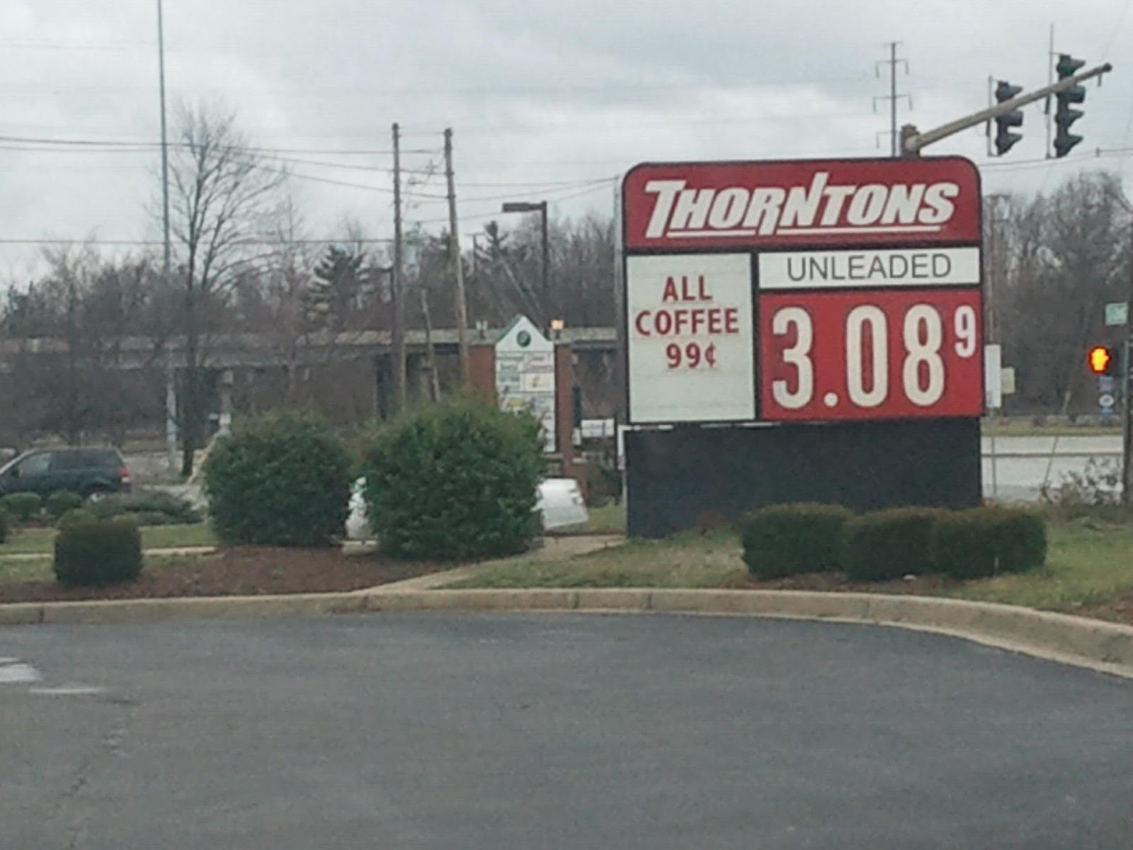
-Get you gas in Louisville! Seriously. Here's the sign at the Thorton's near JAML Corparate HQ's in the east end:
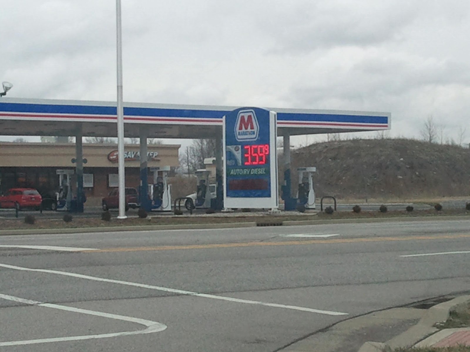
And here it is in Jeff:
I have no idea why there is a $.50 difference, but I believe that its been like that for a couple of days. Save yourself some money.
From the National Weather Service ...LINE OF STRONG TO SEVERE STORMS LIKELY LATE TUESDAY NIGHT AND EARLY WEDNESDAY...
A RAPIDLY STRENGTHENING SURFACE LOW WILL MOVE FROM THE MIDDLE MISSISSIPPI RIVER VALLEY TO THE GREAT LAKES BY DAWN ON WEDNESDAY. A SOLID LINE OF STORMS WILL DEVELOP AHEAD OF A TRAILING COLD FRONT AND WILL MOVE INTO AREAS WEST OF I-65 SHORTLY AFTER MIDNIGHT EST LATE TUESDAY NIGHT...MOVING RAPIDLY EAST TO THE I-75 CORRIDOR BY AROUND DAWN ON WEDNESDAY. VERY STRONG WINDS AND SOMEWHAT UNSTABLE CONDITIONS NEAR THE SURFACE WILL LIKELY ALLOW FOR SOME INSTANCES OF DAMAGING WINDS THROUGH TUESDAY NIGHT. ISOLATED BRIEF TORNADOES WILL ALSO BE A THREAT WITH THIS LINE OF STORMS. STAY UP TO DATE OF THE LATEST FORECASTS AS TIMING OF THIS LINE OF STORMS COULD VARY SLIGHTLY.
OUTSIDE OF THUNDERSTORM WINDS...SUSTAINED SURFACE WINDS OF 20 TO 30 MPH WITH GUSTS BETWEEN 35 TO 40 MPH WILL BE POSSIBLE FROM TUESDAY EVENING...LASTING INTO THE AFTERNOON ON WEDNESDAY.
Yeah, we should have done this last week, but MLK will always get that spot.
On Sunday January 16th, 1994 most of us went to bed expecting some freezing rain then an inch or two of snow. When we woke up on Monday morning we saw the most crippling winter storm that the area has ever seen. What started off as a brief period of freezing rain and sleet, quickly turned to snow. HEAVY SNOW!!! And a lot of it. In less than 10 hours, nearly 16 inches of snow fell across the area. Interstates had to be closed, not just because of the amounts, but because of how quickly it fell. We even had "thundersnow". I actually got to see this. I had fallen asleep on the couch that night watching t.v. and woke up about 2 or 3a.m. As I looked at the window just above me, I noticed there was a flashing light behind the blinds. I peeked between the blinds to catch one last flash of lighting. The snow falling was unbelievable. We already had several inches.
What followed was insanely cold temperatures. Days were we spent most of, if not the whole day, below zero! Louisville set their all time record low that week with -22. I remember waking up that day and my dad telling me I wasn't going playing in the snow because it was too cold. Oh the irony.
When people around here think of snow storms, this is the one that comes to mind first. We've actually had a bigger storm since then, but because of how fast the snow fell and the cold that came afterwards, this is the one that all storms will be measured against. It caused Kentucky and Louisville to tear up their old snow removal plan and come up with a new one. And if you think people panic now over the mention of snow, you should have been around for a couple of years after this storm. Hard to believe that next year will be 20 years. (I'm getting so old)
Here's to you, snow storm of '94. You are the standard.
-Now on to the Wrap Up:
-Really was a slow week again. The biggest story was that the council members who had questions about some of the mayor's expenses now say that those expenses have be adequately explained. While the State Board of Accounts will still do a review, we can and should put this in the rear view mirror. As I stated last week, (I love when I get to do that) that no one should get too upset and just let it play out. It did, and now appears to be a non-story. Whats best for the city is that everyone now moves on.
-The Redevelopment Commission was busy this week as they approved bonds for the new police station, the city's storm water conveyance system (you know the one that completely lacks any imagination or helps the city out in any other way) and a 10 year tax abatement for a Culver's to be located on Veterans Parkway.
Also, Rob Waiz didn't like it when other members questioned his tardiness in regards to him providing a 2013 projects list. Jeez give Rob a break. It's only the end of January of 2013. Whats the rush?
You can read the N&T's full story on the meeting here.
-Want to read something about the council and the mayor agreeing on something? I thought so. Well when the council tabled a request for a 7 and a half million dollar bond to pay for repairs to pumps at Cane Run and Mill Creek, they said they needed more details of the exact cost of the repairs. And you know what? Mike Moore agreed. He said that he himself has been looking for final numbers and hoped to have them for his Flood Control District meeting, but I haven't heard or read anything about it since then.
-I'll admit that I've gotten pretty lucky, but still, has anyone been better at giving you the forecast for Jeff this season?! The JAML Weather Team (probably need a better name than that) has been spot on so far. Keep and eye out this week as well. We'll go from rain tonight and tomorrow, to mid 60's on Tuesday, a chance for severe storms Tuesday night, to wintry weather the rest of the week. As always, I'll keep you up to date!
-The council did approve a ten year tax abatement for a building that will house Re/max. They've already been clearing the land out.
Waiz told the N&T here that "27 jobs, with a total salary of about $1.5 million will be added to the site".
-Finally, Mike Hutt is still watchinig over things. Over on the CCC, he has provided a list of Jeff's top paid employees and vendors for 2012. Have a look see. Neither seem to provide any "eyebrow raisers", but always interesting to see where the money is going.
-That should do it for tonight. As always feel free to comment below and to like the Facebook Page. I'll be back later in the week with another blog post and a new poll. Until then, have a good week everyone!
-Jim Irsay is one cool owner. Indianapolis is lucky lucky to have him!
-Two strippers get into a fight over a tip on stage! 'How much was this' tip you ask. 'Well it had to be at least a hundred dollar bill right' you say. Umm, try taking the two zeros off that total then you'd have your answer. But wait, it gets more ridiculous. Let me quote the story here: The women reportedly exchanged punches and pulled each other's hair until customers and other performers separated them, according to FDLReporter.com. Police were summoned as well. "I was surprised by this as we seldom receive calls for service from this business," Dodge County Sheriff Todd Nehls told the outlet. The women, ages 19 and 23, did not require medical attention after the Jan. 17 incident, although one of them was pregnant at the time of the altercation, Chicagoist reported."
Sorry, no YouTube video. Just imagine your favorite Jerry Springer episode.
Freezing drizzle for another couple of hours. Temperatures are very cold right now for freezing drizzle so this will continue to cause slick spots. As the precipitation tapers off the temperature will begin to rise to slightly above freezing this afternoon which will help road conditions.
AdvisoryURGENT - WINTER WEATHER MESSAGE
NATIONAL WEATHER SERVICE LOUISVILLE KY
320 PM EST THU JAN 24 2013
...WINTRY MIX OF PRECIPITATION EXPECTED FRIDAY MORNING...
.A FAST MOVING LOW PRESSURE SYSTEM WILL PRODUCE A MIXED BAG OF
PRECIPITATION FRIDAY MORNING ACROSS CENTRAL KENTUCKY AND
SOUTHEASTERN INDIANA. MINOR ACCUMULATIONS OF ICE AND SNOW ARE
EXPECTED...BUT TRAVEL IMPACTS WILL BE AGGRAVATED DUE TO
PRECIPITATION OCCURRING DURING THE MORNING RUSH HOUR.
INZ078-079-091-092-KYZ026>043-045>049-053>057-061>067-070>078-081-
082-251000-
/O.NEW.KLMK.WW.Y.0002.130125T0900Z-130125T1900Z/
SCOTT IN-JEFFERSON IN-FLOYD IN-CLARK IN-OHIO KY-GRAYSON KY-
HARDIN KY-BULLITT KY-JEFFERSON KY-OLDHAM KY-TRIMBLE KY-HENRY KY-
SHELBY KY-FRANKLIN KY-SCOTT KY-HARRISON KY-SPENCER KY-ANDERSON KY-
WOODFORD KY-FAYETTE KY-BOURBON KY-NICHOLAS KY-NELSON KY-
WASHINGTON KY-MERCER KY-JESSAMINE KY-CLARK KY-LARUE KY-MARION KY-
BOYLE KY-GARRARD KY-MADISON KY-BUTLER KY-EDMONSON KY-HART KY-
GREEN KY-TAYLOR KY-CASEY KY-LINCOLN KY-LOGAN KY-WARREN KY-
SIMPSON KY-ALLEN KY-BARREN KY-MONROE KY-METCALFE KY-ADAIR KY-
RUSSELL KY-CUMBERLAND KY-CLINTON KY-
INCLUDING THE CITIES OF...SCOTTSBURG...MADISON...NEW ALBANY...
JEFFERSONVILLE...BEAVER DAM...LEITCHFIELD...ELIZABETHTOWN...
FORT KNOX...MOUNT WASHINGTON...SHEPHERDSVILLE...LOUISVILLE...
LA GRANGE...BEDFORD...NEW CASTLE...SHELBYVILLE...FRANKFORT...
GEORGETOWN...CYNTHIANA...TAYLORSVILLE...LAWRENCEBURG...
VERSAILLES...LEXINGTON...PARIS...CARLISLE...BARDSTOWN...
SPRINGFIELD...HARRODSBURG...NICHOLASVILLE...WINCHESTER...
HODGENVILLE...LEBANON...DANVILLE...LANCASTER...RICHMOND...
MORGANTOWN...BROWNSVILLE...MUNFORDVILLE...GREENSBURG...
CAMPBELLSVILLE...LIBERTY...STANFORD...RUSSELLVILLE...
BOWLING GREEN...FRANKLIN...SCOTTSVILLE...GLASGOW...
TOMPKINSVILLE...EDMONTON...COLUMBIA...JAMESTOWN...BURKESVILLE...
ALBANY
320 PM EST THU JAN 24 2013 /220 PM CST THU JAN 24 2013/
...WINTER WEATHER ADVISORY IN EFFECT FROM 4 AM EST /3 AM CST/ TO
2 PM EST /1 PM CST/ FRIDAY...
THE NATIONAL WEATHER SERVICE IN LOUISVILLE HAS ISSUED A WINTER
WEATHER ADVISORY FOR SNOW...SLEET AND FREEZING RAIN...WHICH IS IN
EFFECT FROM 4 AM EST /3 AM CST/ TO 2 PM EST /1 PM CST/ FRIDAY.
* TIMING: WINTRY PRECIPITATION WILL DEVELOP JUST BEFORE DAYBREAK
ON FRIDAY...AND CONTINUE THROUGH THE MORNING.
* MAIN IMPACT: PRECIPITATION WILL BE MOSTLY SNOW AND SLEET FROM
THE LOUISVILLE METRO INTO THE BLUEGRASS REGION...WITH MAINLY
FREEZING RAIN ACROSS SOUTH CENTRAL KENTUCKY. AROUND 1 INCH OF
SNOW ACCUMULATION IS EXPECTED IN THE BLUEGRASS. ICE
ACCUMULATIONS OF 1 TO 2 TENTHS OF AN INCH ARE POSSIBLE IN SOUTH
CENTRAL KENTUCKY.
* OTHER IMPACTS: TRAVEL IMPACTS WILL BE AGGRAVATED DUE TO THE
PRECIPITATION OCCURRING DURING THE PEAK MORNING COMMUTING TIMES.
PRECAUTIONARY/PREPAREDNESS ACTIONS...
A WINTER WEATHER ADVISORY MEANS THAT PERIODS OF SNOW...SLEET...OR
FREEZING RAIN WILL CAUSE TRAVEL DIFFICULTIES. BE PREPARED FOR
SLIPPERY ROADS AND LIMITED VISIBILITIES...AND USE CAUTION WHILE
DRIVING.
This looks to be very light for Jeffersonville. However the ground is so cold from the past week that it won't take much precipitation to cause a few slick spots. Be careful in the morning.
Quick post because, well, quite frankly, I'm very busy.
It appears that Mike Moores expenses are legit. He has produced receipts/paper work that council seems to feel sufficiently explain his spending. However, Council President Connie Sellers says that she still wants the state board of accounts to review the mayor's spending. Mike Moore says that its time to move on.
They are both right.
By all means, have the SBOA review the mayor's spending. It wont hurt anyone and it would absolutely eliminate any chance of some people thinking that the mayor got away with something. But until such time that the SBOA present their findings, let it go and move forward as though nothing is wrong. Its what's best for Jeffersonville.
Now the question is how did something that should be no big deal at this time get to be a big deal? Quite frankly we have no way of knowing.
I can see any number of scenarios where anyone involved in this deal is to blame. The mayor could have thumbed his nose at a request from the council. The council could have thought they had something and went full steam ahead. Both sides could have acted as they should and a third party caught wind of it and went to the media. We may never know. Thus, I don't think it is appropriate to place blame on anyone at this time.
So in conclusion, it's time that we move on from this, but also keep an eye and ear out for the SBOA.
Tomorrow we celebrate Martin Luther King Day. While many have kept his fight alive, none were ever to fill the shoes of this great man. I cant believe that anyone ever will. He was a man who had great passion for his cause, yet he chose peace and spoken words as his weapons in this fight. He was able to deliver his message with such eloquence and intelligence that his message still lives on today. And his words were so great, that they used by all people who fight injustice. My writing will in no way be able to do him justice. So take the time and listen to the great man himself:
Now, on to, and back to, the Wrap Up:
-The biggest story of the week came today, as over on the CCC, Steve Voelker is reporting that the council has questions about the mayor's use of his city credit card. You can read the thread here. Steve says that when asked for he receipts, the mayor responded with "they were lost".
While I don't think that there is any reason to make a big deal out of this yet, it certainly needs to be watched. If true, this is big time scandal. But we have a long way to go before we get there. So lets give everyone a chance to have their say and present evidence before we jump to any conclusions.
-Before that, the big news of the week was the interview in the N&T with several council members regarding their working relationship with the mayor. And more specifically, the communication problems they are having with the mayor. You can read the whole story here.
Its basically every thing that you've been told by people like me, or Goliath, or The Oracle for the past year. The mayor seems to have no desire to sit down and discuss plans for the city or his vision with the city council. While the council continues towards finding middle ground to continue the progress the city has seen in the recent past, the mayor seems content to work against or separate of the council. This has been one of my major gripes with the mayor (and of course his complete lack of vision for the city) and he shows no sign of growing up on this matter. He didn't bother to participate in the interview. He could very easily have answered questions without going in to any pending litigation. But he chose not to.
Honestly, all this is though is just making it official what some have tried to deny. There is indeed a communication problem between the council and mayor, and now we have the council side of it. The fact that we do not have the other is no one's fault except for the mayor's.
-Apparently a shower has been installed in City Hall. Why? I have no idea. It's not a big deal either to me, except, I feel that this is the type of action that Mikey would have used against the former mayor. But I will not.
-If you have a chance, be sure to check out the Local Blogs Forum over on the CCC. They were kind enough to invite me to post about mine, and I'm sure they feel the same about yours, should you have one. Or you can talk about the other local sites or post one that you no about that others may not. Great idea by the CCC and definitely worth a look.
-Its going to turn very cold this week. So be prepared and keep in mind that some nights you may need to leave your facets on a drip. There is NO winter relief program from the sewer department.
-Finally, the city approved a Storm Water Master Plan to deal with 200 plus identified drainage and storm Water problems. The plan and its explanation are extremely long and boring, so I'll boil it down to this: Its basically a guidance on where they think they should start based on the size of the problem in each case and the amount of funds available. More than likely we will hear about each one of these projects as they begin, so just remember that we have a plan.
-That will do it for this week. Did you miss me? Should be back a normal schedule this week. Until the feel free to like the Facebook Page or comment below. Have a good week everyone!
I've added the new poll question. This time around I'm asking about the recent interview by the N&T with some of the city council members about their working relationship with the mayor. You can read the article here.
8:20 pm update: just stepped outside and there is a slippery glaze of ice and sleet on both the driveway & the street. Now this is a residential street obviously and not a main road, but be very careful out there tonight.
7:20 pm update: heard there is a wreck on the Sherman Minton bridge that has traffic slowed or stopped.
We are now under a Winter Weather Advisory for possible accumulations of a wintry mix of snow, sleet & freezing rain. While accumulations look light at this time, it could make roads and thus travel tonight & tomorrow morning slick. I will update this post if anything changes.
-One is that this is obviously a video made for the purpose of promoting the mayor that is trying to disguise itself as a legitimate interview. Its corny and cheesy when this done for infomercials. It is somewhat dishonest when its done by an elected official.
-Second, the mayor continues to take credit for jobs he had little or nothing to do with. Accent was all ready building when he took office. Amazon was announced a few weeks after he took office. Not only is he trying to take credit for them, but their existence disproves his theory that the previous administration was having a negative impact on job growth.
-Third, he has no new ideas. Minus a park here or there, he is basically points to projects that were all ready in the works. Tenth street, the pedestrian bridge, the Riverstage and they throw a picture in of the ice-rink. These projects or attractions all ready existed before he took office. And did he try to take credit for the Ohio River Bridges project?
-Lastly. Please I do not want to hear another person say "think about his family". He just used his kids and their pictures in his own political infomercial. If you want someone to start thinking about his family, start with the man in the video.
I have heard that many of you Hoosier right-wing Republican zealots and Tea Partiers out there (whom includes some of my friends and relatives) woke up with a bad taste in your mouths on Nov. 7. I hope you were not too alarmed.
I felt sure that it wasn’t halitosis. I am no doctor, but I highly suspected all along that it was a huge dose of poetic justice spooned up by the (revered by most reasonable people) Richard Lugar.
You should be proud of yourselves. You have ousted one of our greatest modern day statesmen. Now if you would move to Kentucky and talk Mitch McConnell into reaching across the aisle so you could oust him in two years, we Democrats would be forever grateful. Now if your conscience allows, may you have a tolerable Christmas and decent new year.
Your letter to the editor in the Dec. 5, News and Tribune required my response. I’m sure you expect one. Here it is:
I know your fondness for former Sen. Dick Lugar rates right up there with your (real) fondness for me.
I, for one did not wake up with a bad taste in my mouth Nov. 7. I woke up to reality. The reality that We The People, with grim determination, will continue the fight for our Republic. One day at a time, one election at a time.
Merry Christmas,
— Kelly Khuri, Jeffersonville
Please Ms. Khuri, come down off your high horse. You trashed a man who had served his party (and more importantly the people he represents) with honor and dignity. And replaced him with a loud mouth blowhard that couldn't win in the general election, and thus cost your party a seat. You should still be using mouth wash 5 times a day to get that taste out of your mouth.
But your arrogance shows itself here. Instead of admitting a mistake, you choose to move full steam ahead with your idea of what a good candidate is. Well that idea cost Republicans a Senate seat and caused your Tea Party quite a bit of embarrassment.
You took an respected and elder statesman of the Senate and trashed him. Why, because he still believed that reaching across the aisle to band together and compromise was the best way to a productive government. The Tea Party seems to prefer no compromise and sticking to their extremist attitudes.
Funny, because it seems to me that the most productive and and prosperous time for this country in my lifetime was when a Democrat President named Bill Clinton (who some people did not like) and a Republican Congress lead by Newt Gingrich (who some people did not like) stuck to their core values but looked to find common ground and worked for compromise. Now granted, I'm not that old, so I cant speak to the yester-years of decades much past the 90's, but it seemed this was a pretty good time for Americans from my perspective.
Yet despite these facts and a crushing defeat, you continue to stand by you stubbornness in your letter. And that stubbornness shows in your arrogance. Unable to admit a mistake or wrong doing because Richard Lugar wasn't extreme enough for you and your Tea Party. Well let me tell you something about your Tea Party and what it has meant to me. This was my fourth Presidential election to vote in. In those previous elections I have voted for Bush twice and McCain. I was not opposed to voting for Romney either. It was almost 50/50 basically until the time I went to cast my ballot. But the thought of one of your Tea Party extremist as a Vice President was enough to sway me to vote Democratic for the first time. It also lead me vote Democratic for the U.S. Senate seat too for the first time. And going off the history of Lugar's repeated success in elections, I dare say I'm not the only one.
But you probably have already figured that last part out. But I wonder from your letter above if that really means anything to you or if you just think that voters like myself either have it all wrong or don't/shouldn't matter. It seems that your Tea Party after all, doesn't like to see the other side.
But it should. Compromise and working together is what this country was founded on. Hence, the President (elected by all), the Senate (elected by smaller denominations), and the House (elected by even smaller ones). All voices matter and should not be dismissed, as you have done above. I would reconsider such a hard stance if I were you. Your candidate lost, and your got the last seat on the council. Not exactly a ringing endorsement for your Tea Party.
The new poll is posted to the blog. Also, while I'm back from "blog" vacation, I, and the woman that I live with that I'm related to by marriage are on "real" vaction next week. And since news has been short with the holidays, the next week will be light. Full schedule after that!